
What an amazing way to view Melbourne! Paddle along the Yarra river into Melbourne’s heartland. The bush land comes right down to the water’s edge. A great introduction for interstate or overseas visitors. A special experience for a family, friends, or work colleagues. Relaxing and free to explore at your own pace. Join us on a tour, hire a kayak or bring your own kayak down and explore the Yarra at your own pace.
Spot Water Dragons basking in the sun, listen to the bird life and on occasion spot a platypus or Salvador the resident seal. Pack a picnic lunch and stop at Herring island environmental sculpture park or stop by Kanteen for a coffee before continuing your journey. Boathouse Drive is only a short walk from Flinders Street station in the heart of Melbourne city for a day of exploring the historic Yarra river. Enjoy this paddle past the MCG, Royal Botanic Gardens.
Considerations for paddling the lower Yarra
River Rules
Essential equipment
What to wear
River Access
Understanding the water level
Weather
Maps
River Rules
International maritime law requires you to paddle on the right hand side of channels and rivers. As a kayaker you can paddle on the left if you are seeking Lee, just be aware you are on the wrong side of the channel.
Give way to any craft bigger than you and remember on the Yarra river any craft moving down stream has right of way due to the direction of the river flow.
Always wear a Personal Floatation Device (PFD)
When paddling at dawn, dusk or night time make sure your craft is equiped with a 360 degree white light.
Adhere to all river markers and exclusion zones.
Essential equipment
PFD
Pump and bailer
Kayak
Paddle
Spare paddle (incase you lose or break your other paddle)
Dry bag for your valuables (or leave them in the car)
sunscreen
Personal first aid kit
Water bottle
What to wear
Sturdy close toed shoes (old runners are best)
Quick dry shorts
Fleece (Stays warm when wet)
light rain jacket (great as a wind break)
Sun hat
Sun glasses
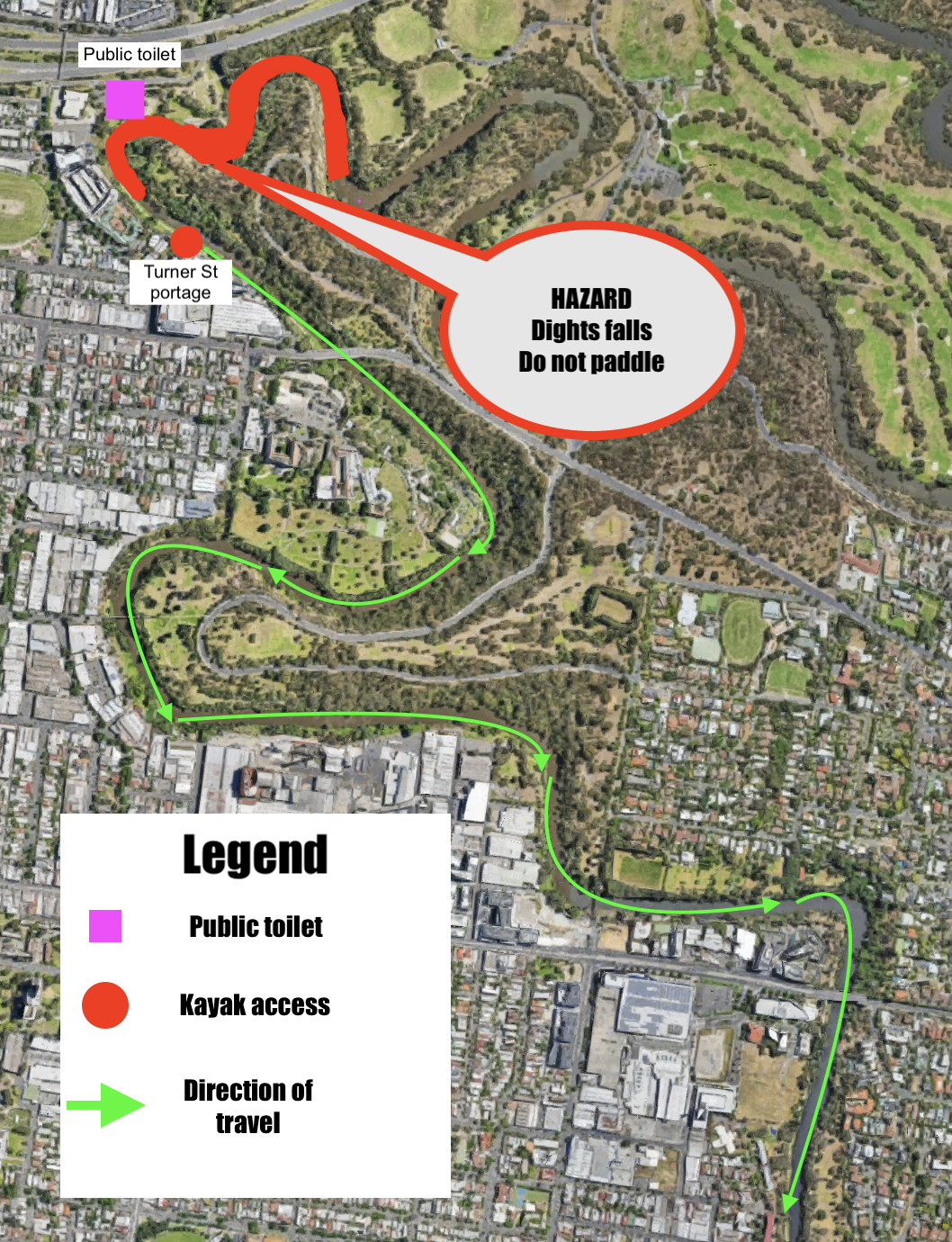
River Access (pictures coming soon)
Turner st portage
Turner St Portage put in is just below Dights falls and allows paddlers to access the river without having to navigate the rapids below dights falls. The put in can be accessed via the bike path and there is parking available on Turner St. The river is constricted here and paddling back up stream can be challenging at low tide as small rapids can form under Johnston St Bridge.
Hawthorn rowing club (Currently under construction)
The Hawthorn boat ramp located at the Hawthorn rowing club is a fantastic put in location with lots of parking available, close to public transport, and easy access to the river. The boat ramp is undergoing works to upgrade ramp to a floating platform. work is expected to last a few more months. until such time this location is unavailable.
St. Kevins rowing club
Just under the M1 St. Kevins Rowing club offers great access to the river with some on street parking available. Be aware that the boat ramp is used by rowing teams and so access may be limited depending on the time of day. bring a trolley for your paddle craft as the walk from the road is down a winding path.
Power House Rowing Club
Power house Rowing club has one of the best boat ramps for accessing the river, it is a floating boat ramp allowing great access at different river heights. Parking is limited to on the street parking as the power house car park is restricted to members and tour operators only.
Wesley Rowing Club
Just around the corner from Power House Rowing Club Wesley Rowing Club grants great access right opposite Herring Island. You are able to get your vehicle close to the boat ramp which is perfect for unloading and loading boats but parking is limited to the street.
Boat House drive
Boathouse Drive gives access to the Yarra right in the heart of Melbourne city. A huge boat ramp means plenty of room to work around other users. be aware that the river is much busier here and so you must adhere to the river rules. Parking is limited and paid but public transport is only 200m away at Flinders street station.
Library at the Dock
The library at the dock is a fantastic location to start and end you paddle with great access tot the water via floating boat ramps. parking can be difficult you you will need to carry or use your trolly to get your craft down to the water.
Understanding the water level
How the tide affects the Yarra river
The lower Yarra River is actually an estuary which means it is a mix on both fresh water and salt water from the bay. Dights Falls in Abbotsford prevents the salt water from going further up stream, this does mean that from Dights falls down the water height is affected by the tide.
When paddling the Yarra River it is important to factor in the tidal movement as this can have a significant affect on the strength of the river flow. When there is an out going tide the Yarra river increases in speed as both natural flow of the river and the tide are working together. For novice paddlers this can make it difficult to paddle back up stream.
The best location to take a tide reading for you yarra paddle is richmond
River Height
When kayaking the Yarra river it is important to be aware of the river height at the location you are paddling as well as the river height up stream as this flows down stream and can change the river height very quickly.
For recreational kayaking we recommend that you only kayak the river when it is below 1.6m measured at Johnston Street Bridge.
The first place you want to go when looking at river heights is the Bureau of Meteorology River Height Bulletin Latest River Heights for the Werribee, Maribyrnong, Yarra, Dandenong, Bunyip this will give you an overview of what is happening in the catchment. For paddling the lower Yarra we have found Johnston Street Bridge to be the best place for current the river height, while checking the height at Fitzimons lane give you a good idea of what is coming down the river.
Why is it important to know the river height
As with all rivers the height fluctuates depending on a variety of factors, dam releases, rain fall, tide heights etc. When the water level rises the river changes and can very quickly become a dangerous environment for example during 2022 Victorian floods the river reached a height of 7m at Johnston street Bridge.
When there is more water in the river; there is increased flow (speed of the river), rapids can form, access to the river can be limited, hazardous debris can be floating down the river and, there can be unseen obstacles just to mention a few examples.
Why do we suggest to only paddle the river below 1.6m (measured at Johnston Street Bridge)?
Looking at the River Height plot’s below we can see that on the 22nd of November 2022 the river was no longer in “Minor flood”, but this doesn’t mean that the water level is safe for kayaking.
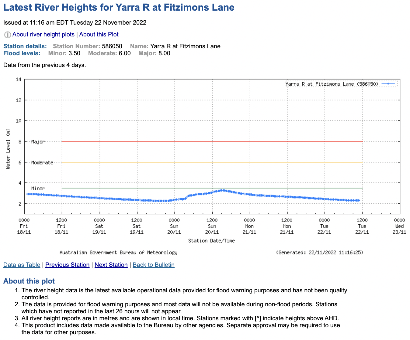
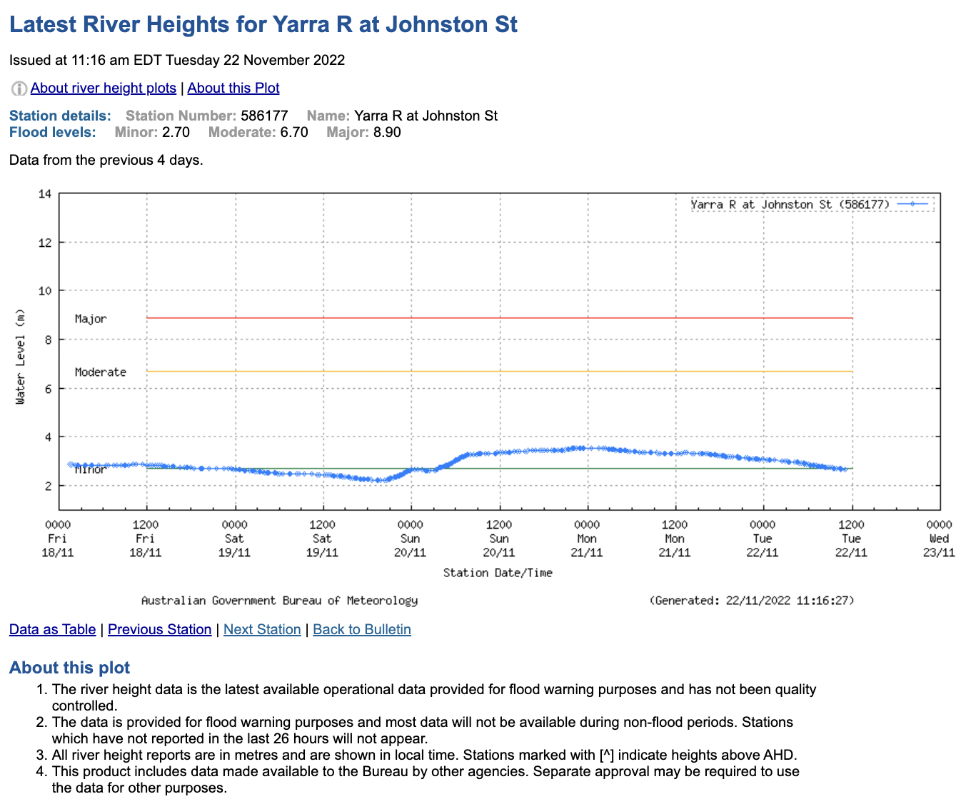
The Yarra river height at Fitzimons Lane is sitting at just over 2m and well below minor flood while the river height at Johnston Street Bridge is sitting just below minor flood at 2.6m. However the river was not safe for recreational kayaking below are some pictures of the river taken on the 22nd of November 2022.


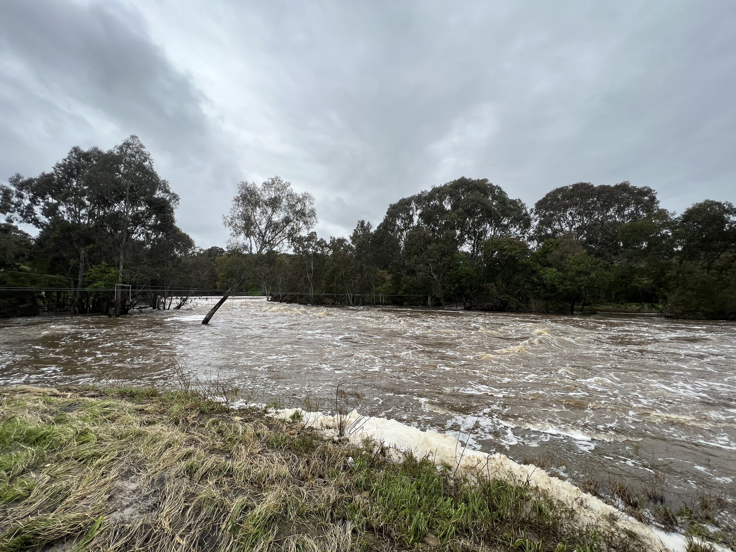


As you can see there is increased flow in the river resulting in white water, footpaths underwater, debris building up on obstacles such as bridges and trees, boat ramps are completely underwater making accessing the river difficult. Paddling the river in conditions like this is dangerous so always make sure you are checking the river height and make informed decisons.
Weather
Kayaking is all about understanding the weather and making good judgment calls about when to paddle and more importantly, when not to paddle.
The wind is key as it plays the biggest part in deciding whether its a great day for paddling or not. When assessing wind speed we use the measurement knots, as a general rule look to avoid paddling in winds blowing speeds of 15 knots or more ,until you have achieved your basics skills certificate in Sea Kayaking.
To interpret the wind forecast you need to understand Fetch and Lee. Watch this video on Fetch and Lee.
WHERE TO GET THE WEATHER FORECAST
Below you will find a list of resources we use to monitor and interpret the weather for our tours, expeditions, courses and hire.
Port Phillip Local Waters Forecast
A great first stop to see what the weather forecast out on the bay is.
http://www.bom.gov.au/vic/forecasts/portphillip.shtml
MetEye Port Phillip and Western Port
MetEye is a fantastic tool and a kayakers best friends for predicting wind.
http://www.bom.gov.au/australia/meteye/?loc=VIC_MW005
256Km Melbourne Radar Loop
The best resource to monitor local rain fall.
http://www.bom.gov.au/products/IDR022.loop.shtml
Willy Weather tides
Willy Weather uses a great graphic to show the tide and relevant height.
https://tides.willyweather.com.au/vic/melbourne/sandringham.html
Bay Winds X
For live updates of wind speeds on the bay.
http://baywx.com.au/
Bay Winds X Fawkner Beacon
Fawkner Beacon measures winds speeds in the Northern half of the bay and is the most relevant measurement location for paddling out of Sandringham.
http://www.baywx.com.au/fbeacon.html
EPA
For all water quality updates.
https://www.epa.vic.gov.au/for-community/summer-water-quality