
The streets of Lancaster have been Googlefied.
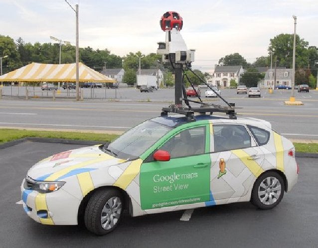
This week, you may have noticed a car with a map-inspired paint job driving around town with a strange cranelike camera on the roof.
Those lucky enough to have witnessed the car, equipped for the search-engine mogul Google, have seen the latest in mapping technology.
Street View gives Googlers a 360-degree view of roads and surrounding areas.
And the driver of the car, Stephen Ruiz of Houston, gets the chance to travel the country.
"It's cool," Ruiz said. "It's something new. I took the job to travel the world, travel the whole United States. I've seen places I've never thought I see."
The weeklong venture through Lancaster has been a treat for Ruiz. He started driving for Google only four months ago, but already he is training others to operate the Street View car.
"I train the people here; then they keep the car. (Google) flies me to a different city, I pick up another car and take that car to another city."
Ruiz explained that learning how to operate the car is not complicated at all.
"(The computer) tells me where to go, and I just follow the route," he said.
Ruiz drives the car for eight hours every day. When Friday rolls around, the company flies him back to Houston for the weekend. The following week, he's back on the road.
Last week he toured Minnesota, and he has traveled through Baltimore and his favorite city so far, St. Louis. He hopes to visit Chicago during his career with Google, but already he finds driving all day tiresome.
"The thing is," Ruiz said with a laugh, "when the camera's on, the radio doesn't work. I have an auxiliary cord, so I can listen to my iPod and CDs, but it gets boring listening to the same songs."
While the camera is rolling, Ruiz must pay attention to the position of the sun so as not to pick up shadows from surrounding buildings that might distort the picture image. He must also pay attention to weather conditions, including temperature, as well as road closures and construction.
In an effort to give travelers a more customized look at cities, towns and other destinations, Google Maps launched the first Street View fleet of cars in May 2007.
Street View provides Googlers with a 360-degree view of roads and surrounding areas with the option to maneuver the 3-D virtual world as if viewers were actually on the streets.
It enables people to check out the location and features of a shop in town, a new neighborhood or even a proposed vacation spot across the globe.
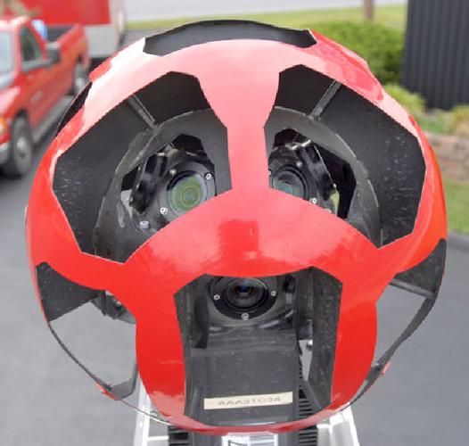
The car is equipped with motion sensors and lasers that help the program map out the 3-D data; one computer that operates everything; and a GPS system. The camera itself has 15 lenses that take overlapping pictures to provide an all-around view.
In addition to cars, Google has equipped bikes to map parks and trails, snowmobiles for arctic conditions and, recently, a small cart trolley for use in museums.
Because of drivers such as Ruiz, Street View now covers locations on all seven continents. To check out where the cars are currently driving, visit maps.google.com/help/maps/s....


