Share

Scan the QR code and open PeakVisor on your phone
Scan the QR code and open PeakVisor on your phone
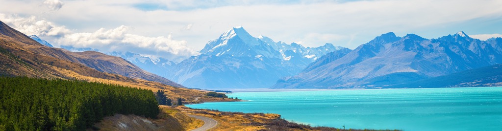
The Queenstown-Lakes District is located in Otago on the South Island of New Zealand. The region spans from alpine zones along the Southern Alps to wetlands and lakes and is lauded as a world-class outdoor recreation destination. The district features no less than 389 named mountains; the east peak of Mount Earnslaw is the highest at 2,830 m (9,285 ft), and Single Cone (2,319 m / 7,608 ft) is the most prominent, rising 1,954 m (6,411 ft) from its surroundings.

The Queenstown-Lakes District in Otago on the South Island of New Zealand is renowned for its outdoor access. From Queenstown on the banks of Lake Wakatipu to the surrounding alpine peaks of the Southern Alps, visitors can mountain bike, hike, boat, ski, cycle, raft, trail run, rock climb, mountaineer, bungee jump, and go horse trekking.
The tallest peak in the region is the east peak of Mount Earnslaw (2,830 m / 9,285 ft). It sits at the head of Lake Wakatipu, with glaciers on the summits of both the east and West peaks. The mountain lies within Mount Aspiring National Park, New Zealand’s third-largest national park, with numerous trails from half-day to multi-day routes.

The Te Wahipounamu UNESCO World Heritage Area covers 2.6 million hectares (6.4 million acres) in the southwest part of the island, spanning approximately 450 km (280 mi) long and 40 to 90 km (25 to 55 mi) inland from the Tasman Sea along the Southern Alps. Major lakes from which the district gets its name are Lake Wakatipu, Lake Wānaka, and Lake Hāwea.
Several smaller ranges, such as the Hunter and Forbes Mountains, are part of the Southern Alps. In addition to the well-known Queenstown, other towns in the district include Wanaka, Glenorchy, and Kingston.
The Remarkables Range is a top skiing destination with its namesake Remarkables Ski Area, located on the backside of Single Cone just outside Queenstown. Coronet Peak and Cardrona are close, and Treble Cone is only an hour and a half drive from Queenstown.

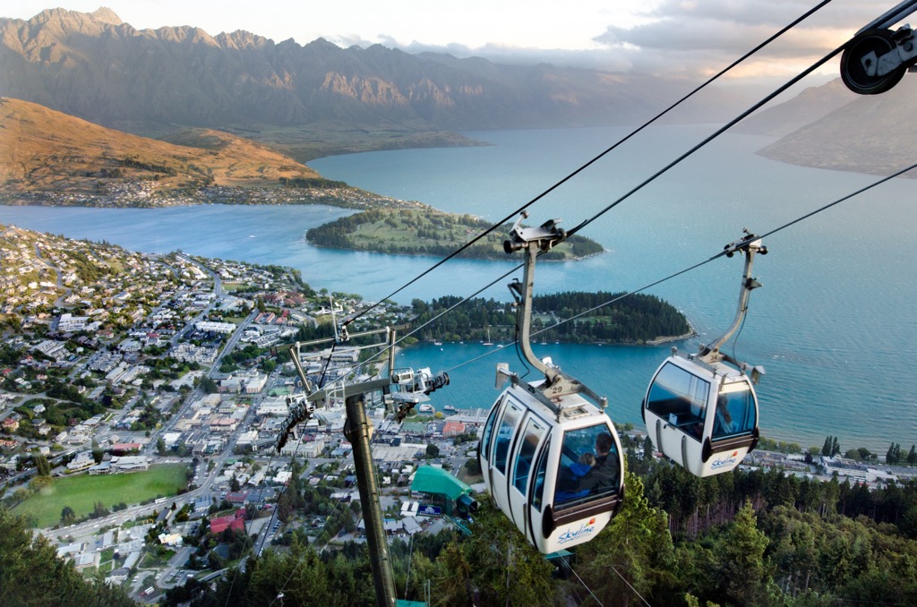
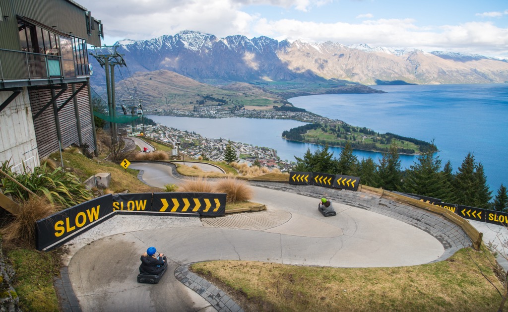
The Skyline Gondola rises about 450 m (1500 ft) out of Queenstown center, accessing hiking trails and a world-class downhill and enduro mountain bike park. A restaurant at the top stations offers a perch for tourists and locals to sit back and enjoy the views with a beverage. The gondola was rebuilt for the spring of 2023 and remains open from September to May, closing only for the winter.

A sandstone called greywacke underlies much of the Queenstown-Lakes District. This rock formed 100 to 300 million years ago on the supercontinent Gondwana. Some parts of the Southern Alps comprise schist, granite, and similar hard, metamorphic rocks.
The landmass of New Zealand separated from the supercontinent Gondwana around 85 million years ago and floated across the Pacific. It came to rest along the boundary between the Pacific and Australian tectonic plates. The collision of these plates uplifted the island, and the ranges seen today formed during the Late Cenozoic. The Southern Alps are one of the fastest-rising ranges in the world. Along with uplift, extreme faulting and folding resulted in the nearly vertical rock faces of the Remarkables Range.

Glaciers existed in the region for much of the past two million years, some up to 1,000 m (3,280 ft) thick. During the last ice age, a glacier carved out the Wakatipu lake bed up to 380 m (1,245 ft) deep. Previous glaciers cut striations into the slopes of Cecil Peak that can be seen today.
The region experienced several gold rushes. These began in the mid-1800s and initially focused on extracting gold from alluvial deposits. Technological advancements over the following decades allowed gold to be extracted from crushed quartz. Mining tapered off by the end of the 19th century.

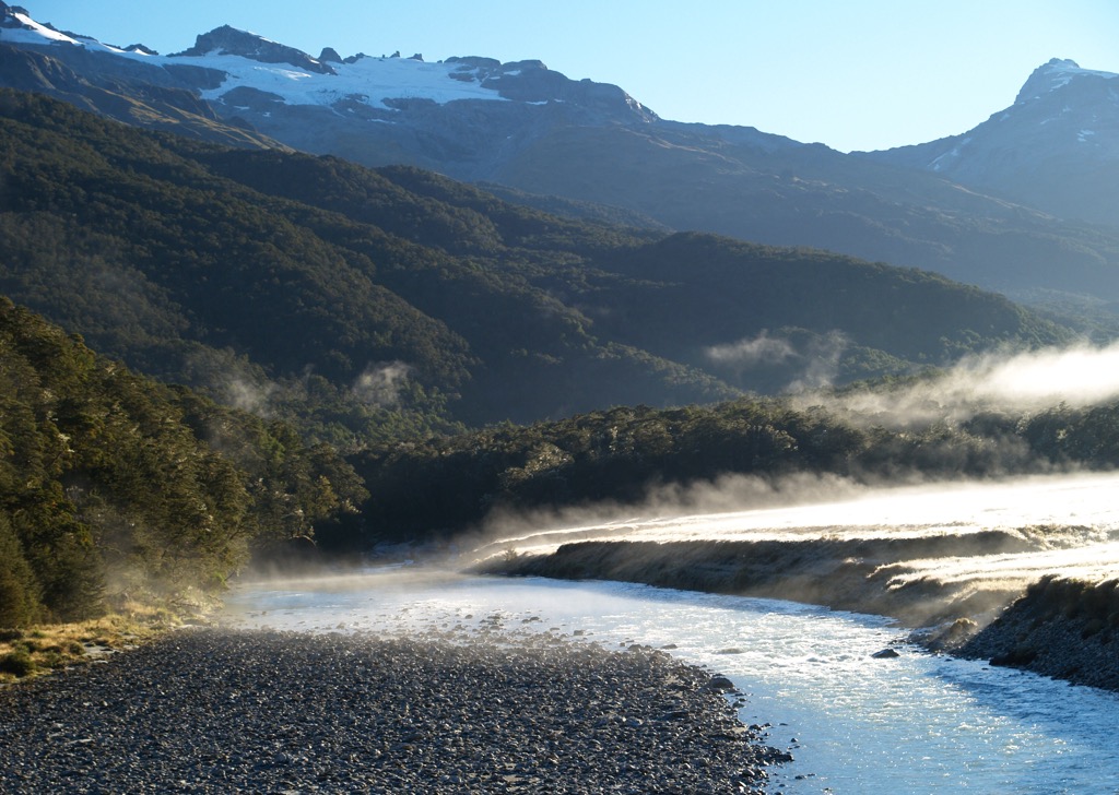
The Queenstown-Lakes District has four distinct seasons and ecosystems ranging from wetlands to alpine zones. The valleys around Mount Aspiring National Park were carved out by glaciers, and glacial-fed rivers still flow through the region.
West of the Southern Alps divide, the slopes receive more rainfall, boast numerous waterfalls, and support thick beech forests and rich birdlife. Along the Eastern flanks, grassy riverbanks give way to slopes and eventually to subalpine zones of tussock, lichens, and small, flowering herbs.

Lake Wakatipu has the uncommon trait of water level rising and falling regularly, with up to 20 cm (8 in) of variation in Queenstown Bay. Early Māori legend explained this rise and fall as the heartbeat of a giant figure lying with his head at Glenorchy, his knees at Queenstown, and his feet at Kingston. Scientists call this occurrence seiche and attribute it to a standing wave caused by atmospheric pressure and wind, which passes every 27 minutes.
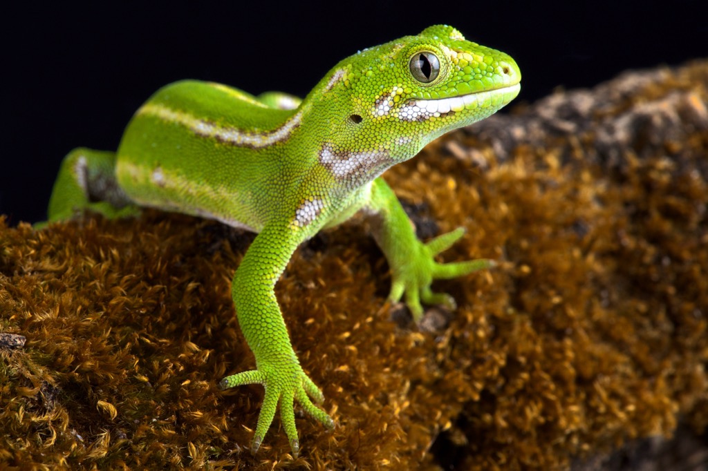
The Southern Lakes Sanctuary protects native fauna, including a wide range of birds, bats, and lizards. The reserve focuses on “high-quality habitat,” meaning areas with more than 30% indigenous vegetation cover. The sanctuary overlaps with portions of Mount Aspiring National Park and the Te Wahipounamu World Heritage area.
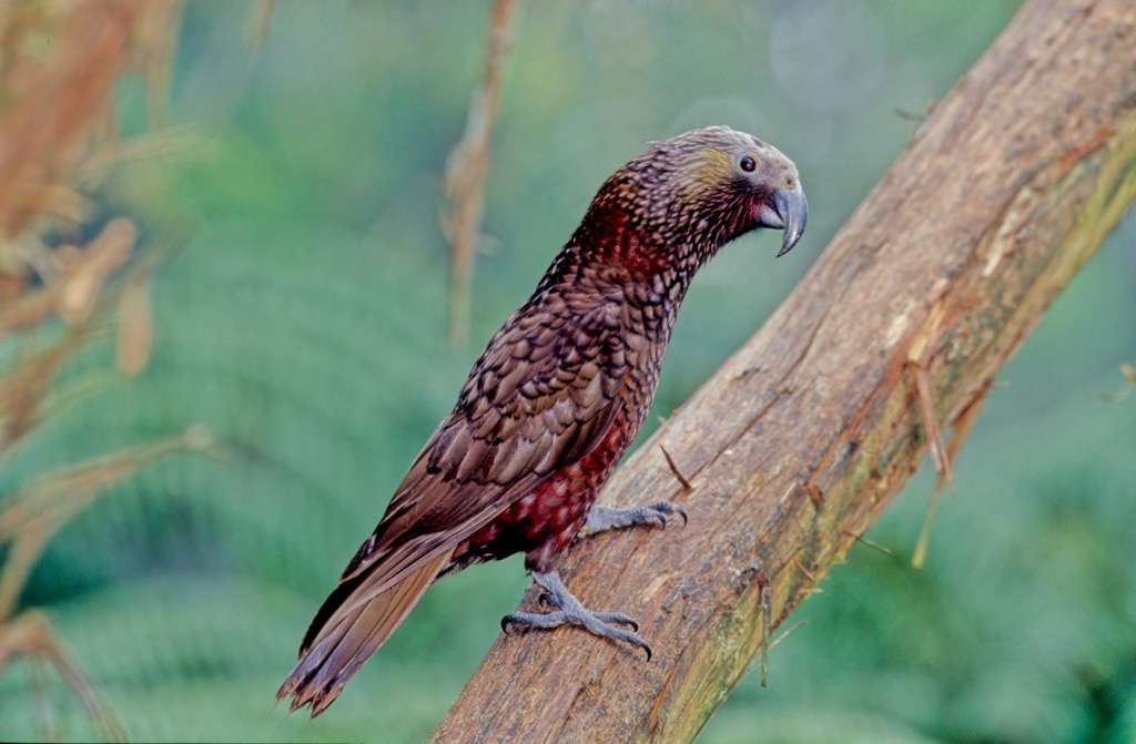
Due to its high rate of species endemism, New Zealand is home to many endangered species. The Lakes Sanctuary is no exception. The threatened and at-risk birds in the sanctuary include the Australasian bittern, black-billed gull, kea, black-fronted tern, rock wren, Australasian crested grebe, blue duck, wrybill, banded dotterel, South Island pied oystercatcher, New Zealand pipit, South Island robin, marsh crake, fernbird, mohua, kākā, New Zealand falcon, and the buff weka.

Threatened lizards include the Otago skink, grand skink, takitimu gecko, lakes skink, orange-spotted gecko, jeweled gecko, Kawarau gecko, southern grass skink, Southern Alps gecko, pallid skink, short-toed gecko, Nevis skink, Humboldt skink, cryptic skink, eyres skink, and korero gecko. The long-tailed bat and South Alps giant wētā (a giant grasshopper-like insect) are also protected within the sanctuary.

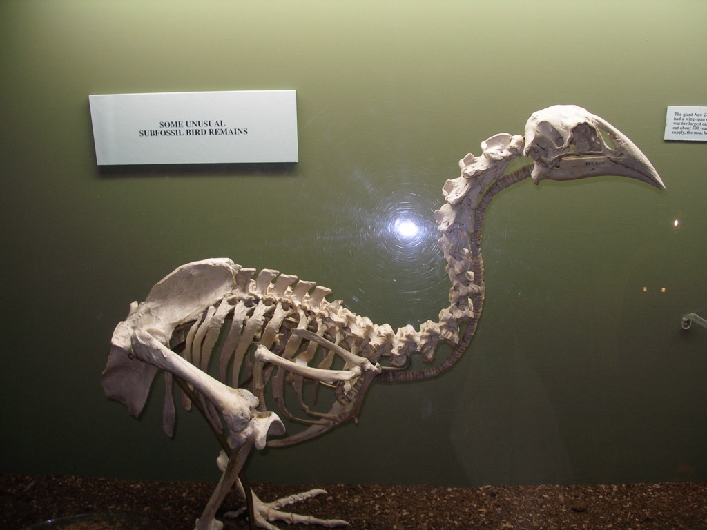
Māori first arrived in the Queenstown-Lakes District around 700 years ago from the valleys of Southland and Otago. Staying in seasonal camps, they hunted the flightless moa and collected pounamu (greenstone). Although most stayed for only the summer, a few groups would remain for up to several years.
In 1860, W.G. Rees & Nicholas Von Tunzelman arrived and promptly burned beech forest and shrubland to make pasture. Following this heavy-handed clearing, settlers planted Douglas fir, larch, sycamore, willow, and poplar trees to diversify the landscape. The fir, in particular, adapted well to this foreign habitat and is an invasive species that still requires management.

European prospectors discovered gold in Arrow River in 1862 and later in Shotover. The gold rush peaked in 1863, but by 1865, the Westland gold rush drew nearly two-thirds of the miners away. Gold was first extracted from alluvial deposits. The advent of new mining technology in the 1870s allowed miners to crush quartz to extract gold, introducing mining in the quartz reefs of Macetown, Mount Aurum, and Shotover River. A historical pack animal trail ran from Queenstown and Glenorchy, and parts are still used today for walking routes.
Fans of Lord of the Rings may stumble upon familiar sites while visiting Queenstown, as the movie filmed multiple scenes in the district.
Today, Queenstown’s economy revolves around tourism, mainly outdoor recreation. The town is known as a hub for any and all outdoor sports, giving it the nickname of the ‘adventure capital of the world.’

Many hikes in the Queenstown-Lakes District range from short strolls along Lake Wakatipu to multi-day treks with stunning ridgelines and glaciers. Below are a few of the most popular hikes in the area.

Summiting Ben Lomond (1,748 m / 5,735 ft) in the Southern Alps is a challenging hike with a 1,438 m (4,718 ft) elevation gain. The out-and-back route takes six to eight hours and is incredibly scenic once past the treeline with views of Cecil Mountain, Walter Peak, and the Remarkables. On a clear day, hikers can spot the towering Mount Earnslaw and Mount Aspiring in the distance.
The trail begins along Tiki Trail in a Douglas fir forest. At around 800 m (2,625 ft) up, the trail crosses beyond the treeline into alpine tussock and shrubland. After passing the saddle, the track is unmaintained and becomes steeper. It cuts through private property, and hikers are asked to be respectful and stick to the trail on their way to the summit.
An alternative option is to take the Skyline Gondola up the mountain and hike from the gondola complex to the saddle. This option is around 4.5 km (2.8 mi), providing hikers with great views for significantly less effort.

The Rees Dart Track is 60.5 km (37.6 mi) point to point with 2,090 m (6,850 ft) elevation gain in Mount Aspiring National Park. Taking four to five days to complete, the trail winds along glacial rivers, waterfalls, montane forests, and alpine zones. It is a challenging route with numerous river crossings and steep, exposed sections.
Several huts along the way are available on a first-come, first-serve basis. Check weather conditions before setting out on this route. Avalanches are more likely to occur in winter and spring but are possible year-round.

Those looking for a shorter trail can take the popular path along the shores of Lake Wakatipu from Twelve Mile Delta to Bob’s Cove, making sure to keep an eye out for marine fossils along the way. The trail is 10.5 km (6.5 mi) out and back and can be hiked or biked with spots along the way to swim. Those familiar with Lord of the Rings may recognize Twelve Mile Delta as the site of Ithilien Camp.
Some of New Zealand’s finest ski resorts are within shouting distance of Queenstown, making the lakes district a fantastic winter destination as well. Follow the links on the resorts below to read our complete guides written by passionate skiers and riders.
A handful of charming towns are dotted throughout the region, including Glenorchy, Kingston, Wanaka, and, of course, Queenstown. New Zealand’s largest cities are Christchurch on the South Island and Auckland as the central international hub on the North Island.
With a population of 15,000, Queenstown is modest but with plenty of personality. It is situated looking out over Lake Wakatipu, and the Remarkable Mountains rise steeply around the town and lake. It’s a popular tourist destination, so expect to pay a little more when staying in town.
That being said, there is plenty to do around town, and it hasn’t become world-famous for nothing. There are water and boating sports on the lake, wine tours, and the option for an adrenaline-rush bungee jumping or swinging from the Nevis Jump. Those looking for a lowkey way to appreciate the outdoors can visit the Kiwi Birdlife Park, home to over 10,000 species of flora and fauna.
Accommodation is available from hostels to hotels, and there is a wide range of restaurants and cuisines to choose from while in town.

Christchurch is New Zealand’s second-largest city, with a population of 381,500. Many hiking trails are easily accessible from the city.
Those looking for a cultural experience can visit the Canterbury Museum for a look at the region’s history, natural history, and artistic tradition. The Christchurch Art Gallery Te Puna o Waiwhetu is the largest museum on the South Island and houses an extensive and frequently updated art collection. The International Antarctic Center provides information on the environment and exploration of the continent, as well as a simulated exhibit for kids.
The city has accommodation ranging from budget backpacker’s hostels to hotels and cozy inns. The food scene is alive and well here, and if you aren’t in the mood for a sit-down meal, be sure to check out the food trucks in Cathedral Square on the weekends.

Auckland is the largest city in New Zealand, with a population of 1.66 million people and home to the main international airport. Although Auckland doesn’t have the charm of some of New Zealand’s smaller towns and cities, it does have beaches, shops, and nightlife.
North Shore is the city’s main beach and is excellent for swimming, surfing, and kayaking. With its protected marine reserve, Goat Island is one of the country’s best snorkeling spots. Waiheke Island is a short ferry ride away, and you can easily spend a day here wandering the beaches, visiting wineries, and hiking along the island’s trails.
One of the most iconic things to do in the city is to go up the Sky Tower, a 328 m (1,076 ft) tall tower. Eat at the rotating restaurant, try bungee jumping, or walk across the tight-rope-esque walkway at the top with a harness.


Explore Queenstown-Lakes District with the PeakVisor 3D Map and identify its summits.