
Overland Australia – Hiking Aournd Moreton Island is a recap of my first circuit of the island (on 2 different occasions). I provide details that include maps, costs, logistical requirements and facts as well as links to additional details, photos and videos. This is a self-guided adventure on a shoestring. Follow the links to dig deeper into the adventure.
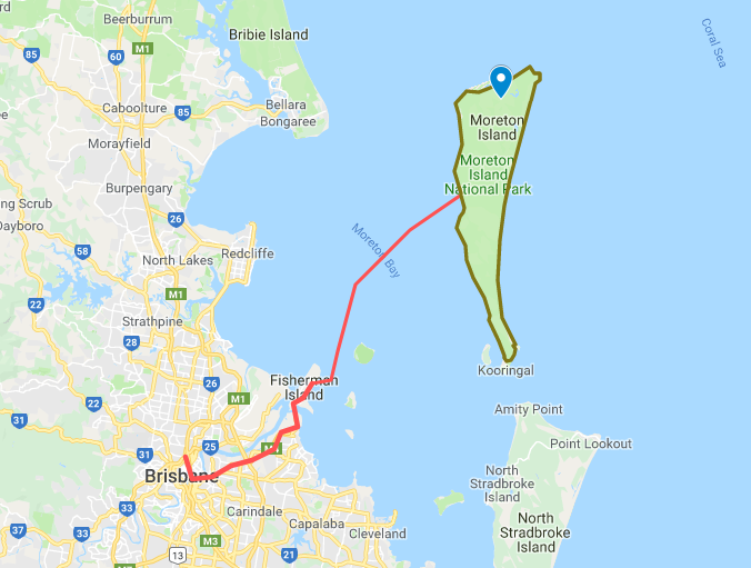
 The jump-off point to start this adventure is the car ferry on Fisherman Island, next to Brisbane, Queensland, Australia. There is also a more expensive non-car ferry option that runs to the Tangalooma Resort. The island is a National Park (visit this site for details), so there are per-night camping fees and sites with facilities (you must pre-book/pay). I paid for sites in advance in the camps but mostly free camped based on where I ended up at the end of each day. There are also a limited number of spots to get supplies. Note that this is a 4×4 fisherman’s Island and not really geared for hikers. The island also has a visitor center with general info.
This is a side adventure while on my How to Overland Australia Sydney to Cape York trip. The next segment is “How to Overland Australia Sydney to Perth.” These posts also contain the interactive Google maps.
 Additional maps can be downloaded here: https://www.tangalooma.com/maps
Hiking Around Moreton Island – My Original Circuit of Moreton Island
The first time I hiked around Moreton Island was on my motorcycle overland trip from Sydney to Cape York. I had previously learned that a motorcycle, even a dirt bike with knobby tires, is no match for loads of soft sand. So I opted to walk (hike) around the island.
Day 1, I take the car ferry called the Morton Venture from Brisbane to Morton Island Tangalooma beach landing. I then walk the west side northward to Cowen (no facilities) and then continue north. The beach has old gun batteries, concrete bunkers, numbers creek crossings and wrecks at the town of Bulwer. The town has fuel, snack shack and a store (open 8am-5pm, closed Tuesdays). At the north end I head east to the Blue Lagoon area where I make a bush camp.
Day 2, From North Point (lighthouse) I traverse the shore (at low tide) along the coast below the cliffs until I reach the open beach. I then head southbound until I run out of day so setup another bush camp.
Day 3, My longest day. I walk half the east side of the island, stopping to observe an Aboriginal Pippies refuse site (like a North American Indian mount site), check out the inside of a WWII gun Battery and observation post, before cutting across island (from east to west) using Kooringal Rd to west shore. Road exits onto mud flats that are easy to cross at low tide. The mud eventually turns to major sand dunes. I continued north to Shark Point (with lots of wrecks buried in the sand). Yet another bush camp.
Day 4, North to Tangalooma beach ferry (3pm) but first I stop at the resort for munchies and a side trip to interior sand dunes. Day ends with a return ferry to Brisbane.
Moreton Island is know for fishing, wrecks and the Tongalooma Resort. Most of the wrecks are located in the beach shallows and easy to explore. However, the Tangalooma beach wrecks are about 100m off shore and can be subject to very strong rip tides. BEWARE.
My Second Circuit of Moreton Island
With fond memories of my prior walk around Moreton, I returned at the tail end of my Overland Australia Sydney to Perth trip.
2017 Video
The outing was much like the first. Harder than I expected. Hot and thirsty most of the time. Didn’t make it to each day’s objective. And all those 4×4 campers with all the luxuries thought I was crazy.
Overland Australia Other Adventures posts:
4×4 Fraser Island Queensland
Noosa Everglades Canoe Trip Queensland
4×4 Cape York Ride Queensland
Kosciusko Summit & MTB Thredbo, NSW
