Famous alternative lifestyle district, now a tourist destination.
Historically Nimbin was a sleepy town in the middle of a dairy and timber district. It was isolated, not on any main roads, and far removed from the major coastal centre of Byron Bay. In 1973 the Australian Union of Students organised an Aquarius Festival in the town and overnight it became a byword for 1970s hippiedom, now amusingly known as "Australia's progressive alternative lifestyle movement", when thousands of students descended on the town. Many stayed and pursued idealistic lifestyles. Today it is a popular tourist destination as people from around the world come to, albeit briefly, participate in the alternative lifestyle choices of healthy food, permaculture and organic growing, and colourful clothing.
Location
Nimbin is located 766 km north of Sydney via the Pacific Highway, Summerland Way, Casino and Lismore, and 179 km south of Brisbane via Murwillumbah.
^ TOPOrigin of Name
The original Aboriginal inhabitants were the Bundjalung, Nimbinjee and Whiyabul people. It is likely that the town's name is a corruption/abbreviation of Nimbinjee.
^ TOPThings to See and Do
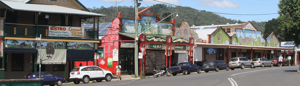
Cullen Street
For most visitors Nimbin is a different world. It is like no other rural town. It is characterised by brightly coloured, often psychedelic, mural facades and shopfronts that are designed to create an alternative ambience. It is a town where vegetarianism, alternative health therapies, craft shops and candle factories are vital parts of the local scenery. To wander along the main street of Nimbin is to experience such shops and facades as the Green Bank, the H.E.M.P. Embassy, the H.E.M.P. Bar, the Nimbin Craft Gallery, Happy High Herbs, Tribal Magic, the Environmental Centre, the Nimbin Mad Hattery and Perceptios Books. The cafes serve wholesome and unusual food. The shops are full of crafts. This is the heart of the Nimbin experience. Walk along the street and absorb the atmosphere. The Nimbin Visitor Centre has a map but it is hardly necessary as all activity in the town is located on Cullen Street.
Nimbin Rocks
The remains of ancient, eroded volcanic dykes the Nimbin Rocks are located on the Lismore Road 3 km south of the town. It has been estimated that they are between 20-23 million years old and are a southern inland section of the gigantic Tweed caldera, a vast super-volcano which covered 4,000 square kilometres from Coraki in the south to Beenleigh in the north, west to Kyogle and east beyond the coast where it formed islands (Cook Island) and dangerous reefs. It is believed that the rocks were known to the Bundjalung Aboriginal people as an important sacred burial site and as the home of Nyimbunji, a spirit man who watched over the surrounding country. They can be seen on the west side of the road.
St Stephens Presbyterian Church
Down the southern end of Cullen Street is the very simple, timber Presbyterian Church which was opened on 22 September, 1922. Ministry was by foot until a horse and sulky were provided and then by pushbike in 1928. Services are held on the first Friday of each month at 10.00am. The church still has its original pump organ.
Other Attractions in the Area
Nightcap National Park
The ridges, peaks and gullies of Nightcap National Park (4945 ha) consist of solidified and eroded lava from the gigantic Tweed caldera, a vast super-volcano which covered 4,000 square kilometres from Coraki in the south to Beenleigh in the north, west to Kyogle and east beyond the coast where it formed islands (Cook Island) and dangerous reefs..
The fertile soil which derived from the rock, together with the state's highest rainfall, has created one of the finest sections of subtropical rainforest in New South Wales. Some of the park's enormous brush box are thought to be up to 1500 years old. The park is also of spiritual importance to the Bundjalung Aboriginal people and is now World Heritage listed. For more information about the walks in the area check out http://www.environment.nsw.gov.au/NationalParks/parkWalking.aspx?id=N0062.
There are two main locations for vehicle-based visitors in the park: Mount Nardi and Terania Creek.
Mount Nardi and Pholis Gap
Mount Nardi is one of the park's highest peaks. To get there take the right-hand fork at the Nimbin Hotel and head out of town on Sibley Street. Follow the road for about 14 kilometres. There are visitor facilities at the summit and a 3 km loop walking track (90 minutes) to Mount Matheson. From Mount Matheson the track leads east, eventually linking up with the Nightcap Track. The latter was originally a pack-horse trail constituting the first overland link between the Richmond and Tweed Valleys.
Pholis Gap Walk is a 4 km link track that leads from the Matheson Track to Pholis Lookout (named after Athol Pholi who was killed by a falling tree). The lookout provides outstanding views of the Tweed and Doon Doon Valleys. The National Parks website notes: "The track meanders through lush rainforest of yellow carabeen and towering brushbox. You might see Albert’s lyrebirds and brush turkeys darting through the understorey. Descending westwards, look for grass trees and New England blackbutt along the drier ridges."
Terania Creek and Protesters Falls
To reach Terania Creek Picnic Area take the turnoff to The Channon. Beyond The Channon follow Terania Creek Road. After 9.5 km the visitor reaches the Terania Creek Picnic Area. It is a 1.4 km return walk (it takes around 40 minutes) to Protesters Falls which are set in particularly dense rainforest featuring thickets of bangalow palms and native tamarind. The falls were named after the protesters who carried on an anti-logging campaign here in 1979 which led to the declaration of the national park in 1983. Another walk follows an old logging track adjacent to Terania Creek. There is detailed information at http://thechannon.com.au/attractions/protesters/index.html.
The Channon
The Channon is an attractive village halfway between Nimbin and Lismore. It is surrounded by an agricultural area known for permaculture and organic farming. The village is perched on a hilltop which is home to a vibrant artistic alternative community. The village is named after a local palm which, it is believed, helped Bundajung Aborigines to find their way to the coast. The centre of the cultural life of the village is the tavern and The Channon Craft Market which is held on the second Sunday of each month. For more information check out http://thechannon.com.au.
History
* Prior to European settlement the area was inhabited by the Bundjalung, Nimbinjee and Whiyabul Aborigines.
* European timber cutters reached the area in the 1840s. They were searching for red cedar and other subtropical hardwoods.
* The area was subdivided into agricultural holdings in 1903.
* It was gazetted in 1906.
* When the timber was exhausted the land was cleared for dairy and banana farming.
* By 1908 a local Dairy Co-operative was established.
* By the 1930s Italian immigrants were growing bananas of the hills around the town.
* The town's dairy industry declined dramatically in the 1960s.
* In 1973 the Australian Union of Students (AUS) chose the Nimbin Valley as the venue for the experimental lifestyle Aquarius Festival. The festival was to be "a total, cultural experience through the lifestyle of participation" and attracted students and alternative lifestyle enthusiasts from all over Australia. A small number stayed on and formed the basis of a lifestyle experiment which emphasised sustainability and organic farming.
* Shortly after the Aquarius Festival the Tuntable Falls Co-ordination Co-operative was established. It purchased 486 hectares for $100,000 and sold 500 shares in the co-operative for $200 each. This led to the establishment of other co-operatives including the Paradise Valley Pastoral Company. The 'alternative society' has been able to prosper because this is impossibly rich land with a rainfall which ranges from 1500-2000 mm per year and which is ideal, particularly in the pockets of rich rainforest, for the growing of bananas, paw paws, mangoes and kiwi fruit.
* People who settled in the area were deeply committed to alternative forms of agriculture. Today, local practitioners of permaculture, organic food growing and energy efficiency live on the land around the town.
* In 1979 the Battle of Terania Creek was held at Protesters Falls. it was instrumental in protecting the rainforest in the area.
* In 1996 Nimbin became a sister town with Woodstock in the USA.
* In 2008 the town was raided by 110 police officers trying to clamp down on marijuana usage. It is illegal in New South Wales.
* In August 2014 a fire destroyed three of the town's most famous alternative lifestyle buildings - the Nimbin Museum, Bringabong and the Rainbow Cafe.
^ TOPVisitor Information
Nimbin Visitor Centre, 3/46 Cullen Street, tel: (02) 6689 1388.
^ TOPUseful Websites
There is a useful, downloadable brochure at http://issuu.com/lismorecitycouncil/docs/nimbin_2015 which combines a map with a good overview of the town. There is a community website at http://www.nimbinweb.com.au.
^ TOP
Economically how prosperous is Nimbin now, has the population declined do they have a mental health issue in Nimbin due to excess use of artificial drugs? What are the future productive plans of the council for Nimbin? When I visited although briefly, for lunch, there were a few people wondering around asking for money, some with mental issues.