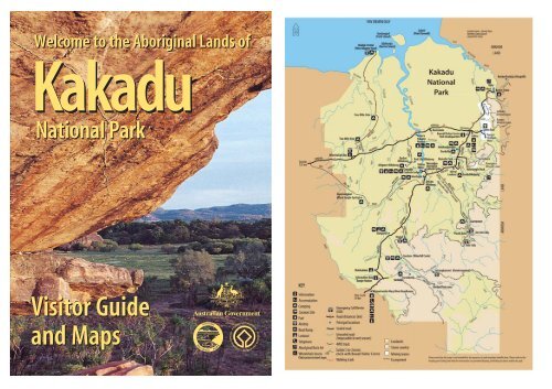
Kakadu National Park Visitor Guide and Maps - Free
Kakadu National Park Visitor Guide and Maps - Free
Kakadu National Park Visitor Guide and Maps - Free

You also want an ePaper? Increase the reach of your titles
YUMPU automatically turns print PDFs into web optimized ePapers that Google loves.
Welcome to the Aboriginal L<strong>and</strong>s of<strong>Kakadu</strong><strong>National</strong> <strong>Park</strong><strong>Visitor</strong> <strong>Guide</strong><strong>and</strong> <strong>Maps</strong>
Welcome to <strong>Kakadu</strong>The Board of Management <strong>and</strong> park staff welcome you to <strong>Kakadu</strong>. On behalf ofthe Aboriginal traditional owners, we hope you will enjoy learning about culture,l<strong>and</strong> management <strong>and</strong> caring for country.<strong>Kakadu</strong> is a cultural l<strong>and</strong>scape. It was shaped by the spiritual ancestors ofAboriginal people during the Creation Time. These ancestors or ‘first people’journeyed across the country creating the l<strong>and</strong>forms, plants, animals <strong>and</strong> Bininj/Mungguy (Aboriginal people). They brought with them laws to live by: ceremony,language, kinship <strong>and</strong> ecological knowledge. They taught Bininj/Mungguy how tolive with the l<strong>and</strong> <strong>and</strong> look after the country.The name ‘<strong>Kakadu</strong>’ comes from an Aboriginal floodplain language called Gagudjuwhich was one of the languages spoken in the north of the park at the beginningof the twentieth century. Although languages such as Gagudju <strong>and</strong> Limilngan areno longer regularly spoken, descendants of these language groups are still living in<strong>Kakadu</strong>. Aboriginal languages used in the park today include Kunwinjku from thenorth-eastern region, Gun-djeihmi from the central region <strong>and</strong> Jawoyn from thesouthern region.<strong>Kakadu</strong> <strong>National</strong> <strong>Park</strong> is a Commonwealth Reserve covering almost 20 000 squarekilometres, <strong>and</strong> includes the traditional l<strong>and</strong>s of a number of Aboriginal clangroups. <strong>Kakadu</strong> is managed jointly by its Aboriginal traditional owners <strong>and</strong> theAustralia Government Department of Environment <strong>and</strong> Heritage.'If you respect the l<strong>and</strong>,then you will feel the l<strong>and</strong>.Your experience will be one that youcannot get anywhere else in the world.'Brian Baruwei - Wurrkbarbar clan.Aboriginal traditional owner.<strong>Park</strong> Laws<strong>Kakadu</strong> <strong>National</strong> <strong>Park</strong> is a Commonwealth Reserve under the EnvironmentProtection <strong>and</strong> Biodiversity Conservation Act 1999. As a result, the laws in<strong>Kakadu</strong> differ in some ways from other areas within the Northern Territory. Formore information please call the Bowali <strong>Visitor</strong> Centre on (08) 8938 1120.Bininj (pronounced Bin-ing) is a Kunwinjku <strong>and</strong> Gun-djeihmi word,Mungguy (pronounced Moong-gooy) is a Jawoyn word. Both are similar tothe English word man <strong>and</strong> depending on the context can mean man, male,person or Aboriginal people.23
Finding your wayThis guide is divided into seven visitor areas. Each area is illustrated with a smallmap <strong>and</strong> a brief description about the places of interest. Unless otherwise stated,access is 2WD <strong>and</strong> generally open all year.Information BayContentsIntroduction<strong>Kakadu</strong>, a World Heritage AreaIntroduction to Bininj/Mungguy (Aboriginal) waysPronouncing Bininj/Mungguy names<strong>Kakadu</strong>'s habitatsThe role of fire<strong>Maps</strong> & Places of Interest<strong>Kakadu</strong> <strong>National</strong> <strong>Park</strong> Map1. South Alligator Area2. Jabiru Area3. East Alligator Area4. Nourlangie Area5. Yellow Water Area6. Mary River Area7. Jim Jim Area677810112141618202224Information BayRanger StationSafetyCrocodilesSurviving the tropicsDriving hintsActivitiesExploring Aboriginal cultureBoating <strong>and</strong> fishingBushwalkingViewing the wildlife25262728293031Wheelchair accessTracks <strong>and</strong> toilets suitable for wheelchair access areprovided at the Bowali <strong>Visitor</strong> Centre <strong>and</strong> WarradjanAboriginal Cultural Centre; Merl, Muirella <strong>Park</strong>, Mardugal<strong>and</strong> Gunlom camping areas; <strong>and</strong> at Ubirr <strong>and</strong> Nourlangieart sites. Mamukala <strong>and</strong> Yellow Water have wheelchairaccess tracks but no toilet facilities.4Suggested itinerariesFurther information53233
<strong>Kakadu</strong>, a World Heritage AreaIntroduction to Bininj/Mungguy (Aboriginal) ways<strong>Kakadu</strong> <strong>National</strong> <strong>Park</strong> is one of the few World Heritage Areas that have beenlisted for both their cultural <strong>and</strong> natural heritage. The park protects one of thefinest <strong>and</strong> most extensive collections of rock art in the world, a tangible reminderof Aboriginal people’s long <strong>and</strong> continuing association with the area.<strong>Kakadu</strong> protects examples of most of Australia's Top End habitats, including theentire catchment of a large tropical river, the South Alligator. From this range ofhabitats stems a remarkable abundance <strong>and</strong> variety of plants <strong>and</strong> animals. Manyare rare or not found anywhere else <strong>and</strong> new species continue to be discovered.This World Heritage emblemsymbolises the interdependenceof cultural <strong>and</strong> naturalproperties: the central square isa form created by people <strong>and</strong>the circle represents nature.The two are intimately linked.You can help care for yourself <strong>and</strong> <strong>Kakadu</strong> by following these guidelines:• Walk only on marked tracks.• Avoid damaging Aboriginal rock paintings by staying behind the barriers.• Protect plants <strong>and</strong> do not use tree branches as fly swats.• Do not feed or disturb wildlife.• Light fires only in fireplaces provided.• Use as little firewood as possible or use fuel stoves.• Camp only in designated camping areas.• Drive carefully <strong>and</strong> keep to the roads <strong>and</strong> carparks.• Obey warning signs.6<strong>Kakadu</strong> <strong>National</strong> <strong>Park</strong> is home to many Aboriginal people. As in most cultures,Bininj/Mungguy culture has its own set of social behaviours <strong>and</strong> customs, whichare considered good manners. Please consider these while visiting <strong>Kakadu</strong>.• Religion <strong>and</strong> ceremony are very important parts of Bininj/Mungguylife. Show respect by not entering restricted areas such as sacred sites,ceremonial sites or burial grounds.• Traditionally Bininj/Mungguy do not greet each other everytime they meet. However, most Bininj/Mungguy are used to non-Aboriginal people doing so <strong>and</strong> may expect a ‘hello’.• Many Bininj/Mungguy do not use personal names as freely as non-Aboriginal people do <strong>and</strong> often address each other by kinship terms.• Bininj/Mungguy appreciate privacy. It is good manners not to enterliving areas <strong>and</strong> not to take photographs of Bininj/Mungguy withoutpermission.• Some Bininj/Mungguy find constant eye contact uncomfortable.• In Bininj/Mungguy culture, it is important to pay attention, <strong>and</strong> toconsider your questions carefully.• It is polite to say ‘good bye’ when leaving. In this area the Bininj/Mungguy word for good bye is boh boh (pronounced bor bor).• In Bininj/Mungguy culture, it is often not appropriate to use thenames or display images of deceased people.• Areas may close at short notice for cultural purposes at the requestof traditional owners.Pronouncing Bininj/Mungguy namesUnlike English, the spelling system used to record local Aboriginal languages isvery consistent. So once you have learnt the alphabet, it is quite easy to pronouncewords by sounding them out.The Aboriginal Language <strong>Park</strong> Note details the Gun-djeihmi alphabet. It isavailable from the Bowali <strong>Visitor</strong> Centre. In this guide, English approximations forsome names are given in brackets.7
<strong>Kakadu</strong>'s habitatsSavanna woodl<strong>and</strong>sTravelling anywhere in <strong>Kakadu</strong>, youcan’t help but notice the woodl<strong>and</strong>swhich make up nearly eighty percent ofthe park. Consisting mostly of eucalypts<strong>and</strong> tall grasses, at first glance theymight seem lifeless <strong>and</strong> monotonous.However, the woodl<strong>and</strong>s support agreater variety of plants <strong>and</strong> animalsthan any other habitat in the park.Road side, South Alligator Area, dry season.Monsoon forestsUnlike the expansive woodl<strong>and</strong>s,monsoon forests occur in small,isolated patches. Fruit-eating birds <strong>and</strong>flying foxes help to link the plants inthese isolated pockets of forest togetherby dispersing pollen <strong>and</strong> seeds as theymove around.Stone countryTo the east of the <strong>Kakadu</strong> Highway isthe dominating s<strong>and</strong>stone escarpmentof the Arnhem L<strong>and</strong> Plateau. It rangesin height from 30 metres to 300 metres.In some areas the escarpment is erodingby up to one metre every thous<strong>and</strong>years, leaving behind rock shelters <strong>and</strong>outliers like Ubirr <strong>and</strong> Nourlangie.Nawurl<strong>and</strong>ja lookout, Nourlangie Area, wet season.Floodplains <strong>and</strong> billabongsFloodplains such as the South Alligatorfloodplain visible from the ArnhemHighway undergo dramatic seasonalchanges. Following wet season rains,a sea of shallow freshwater spreadsover the plains for hundreds of squarekilometres. As the floodplains start todry, waterbirds <strong>and</strong> crocodiles seekrefuge in the remaining wet areas suchas Yellow Water Billabong.Ngurrungurrudjba (Yellow Water), dry season.Manngarre walk, East Alligator Area, dry season.Southern hills <strong>and</strong> ridgesIn the south of the park, hills <strong>and</strong> brokenridge lines are the result of millions ofyears of erosion. The unusual geology ofthis area is reflected in the diversity ofhabitats <strong>and</strong> the presence of plants <strong>and</strong>animals that do not occur anywhere elsein the world.Gimbat road side, Mary River Area, dry season.Tidal flats <strong>and</strong> coast<strong>Kakadu</strong> protects almost 500 squarekilometres of coastal <strong>and</strong> estuarineareas, as well as two isl<strong>and</strong>s. Most ofthese areas are lined with mangroveforests which form an importantnursery for many fish includingbarramundi. <strong>Kakadu</strong>’s wetl<strong>and</strong>s,which include floodplains, billabongs,rivers, coastal <strong>and</strong> estuarine areas, arerecognised internationally as beingsignificant for migratory birds.Waldak Irrmbal, West Alligator Head, dry season.89
The role of fireFire has a major influence on the Australian environment <strong>and</strong> has shaped many ofthe plant communities we see today.Traditional burningFire has been an important part of Aboriginal life for thous<strong>and</strong>s of years. It wasused to signal others <strong>and</strong> is still used for cooking, to make hunting easier, toattract animals, to protect foods such as yams <strong>and</strong> to 'clean the country' before thehot dry weather comes.This earth, I never damage.I look after. Fire is nothing, just clean up.When you burn, new grass coming up.That means good animal soon,might be goanna, possum, wallaby.Burn him off, new grass coming up, new life all over.Bill Neidjie - Bunitj clan.Aboriginal traditional owner.Changes to traditional burningFires lit by Bininj/Mungguy as theytravelled to different parts of thecountry created a patchwork ofburnt <strong>and</strong> unburnt areas. With thearrival of non-Aboriginal people,the Bininj/Mungguy populationdecreased. Many people died ofdisease, others moved off theirl<strong>and</strong> to towns <strong>and</strong> settlements.With fewer people on the l<strong>and</strong>, lessburning was carried out, so hot, latedry season wildfires became morecommon. These hot fires were oftenlarge <strong>and</strong> destructive, changing thedistribution of plants <strong>and</strong> animals.Planned burningSince the 1980s, Bininj/Mungguy<strong>and</strong> park managers have workedtogether to reduce the number of hotfires at the end of the dry season.Burning around p<strong>and</strong>anus palms.Most burning takes place in the early dry season (May to July) when conditionsare relatively cool. These fires are generally of low intensity, <strong>and</strong> of little risk tohumans <strong>and</strong> most animals. Damp areas, left over from the wet season, help tobreak up fires <strong>and</strong> create a patchwork pattern of burnt <strong>and</strong> unburnt areas.Although late dry season fires (September to November) are generally avoided,some floodplain burning, often by Bininj/Mungguy hunting goannas <strong>and</strong> turtles,does occur. Fires are also lit by lightning strikes at this time of the year. Wet seasonburning is used to reduce the amount of flammable spear grass (Sorghum spp)before the dry season.Reducing the risk of wildfires©Alderson,Gangali<strong>and</strong> Haynes (1979)The Gundjeihmi Aboriginal Calendar shows lighting fires is part of the yearly cycle.Please help prevent wildfires. Make sure your cigarette butts <strong>and</strong> matches areout <strong>and</strong> put them in rubbish bins, not on the ground. Clear the area around yourcampfire <strong>and</strong> put it out before you leave.Fire as part of our environmentUsing fire wisely, for the right purposes at the right time, will ensure Australia’sunique environment is maintained for present <strong>and</strong> future generations.1011
1. South Alligator AreaIf you have more timeGu-ngarre (Goong-narr-ee) walkWhere: Starts at the large banyan figtree near the Aurora <strong>Kakadu</strong> Resort.Features: A 3.6 km circular walkthrough monsoon forest <strong>and</strong> woodl<strong>and</strong>s<strong>and</strong> along the margins of a billabong.Allow 2 hours.South Alligator River <strong>and</strong> picnic areaWhere: Near the South Alligator Bridgeon the Arnhem Highway.Magpie goose (Anseranas smipalmata)Places to stayAurora <strong>Kakadu</strong> ResortMotel rooms, tent sites, powered<strong>and</strong> unpowered van sites, restaurant,cafe <strong>and</strong> store. Pool for guests only.Reservations recommended, telephone(08) 8979 0166.Bush camping areas (check wet season access)<strong>Free</strong> camping with basic or no toiletfacilities is available at Two Mile,Four Mile Hole, Red Lily Billabong,Bucket Billabong, Alligator Billabong<strong>and</strong> Waldak Irrmbal (West AlligatorHead). See inside cover map for roadaccess. Drinking water is not available.Rubbish bins are not provided, bringrubbish out with you.ServicesThe <strong>Kakadu</strong> Resort store sells petrol,LPG gas (LPG bottle refills only),diesel, food <strong>and</strong> souvenirs.Main AttractionMamukala (Mar-moo-car-lar) wetl<strong>and</strong>sWhere: Turn south off the ArnhemHighway 7 km east of the SouthAlligator River.Features: Mamukala is beautiful allyear but at its most dramatic in thelate dry season (Sept - Oct) whenthous<strong>and</strong>s of magpie geese congregateto feed. An observation platform allowsyou to view the birdlife while a muralillustrates the seasonal changes thatoccur through the year. There is alsoa 3 km walk adjacent to the wetl<strong>and</strong>s.Allow 1 to 2 hours for the full walk.Features: Picnic tables <strong>and</strong> barbequeareas.Boat ramps: At the northern end of thecarpark (see page 29 for more boatinginformation).Off the highway (dry season only, 4WD)Where: There are two major fourwheel drive tracks in this area: theWaldak Irrmbal (West Alligator Head)Magpie geese in flight.track (which accesses Two Mile Hole,<strong>and</strong> Four Mile Hole) <strong>and</strong> the RedLily, Bucket Billabong <strong>and</strong> AlligatorBillabong track (see inside cover map).Features: Both tracks take you todestinations suitable for boating, birdwatching <strong>and</strong> camping.Please read the crocodile informationon page 25.1213
2. Jabiru AreaMain AttractionBowali (Bor-warl-ee) <strong>Visitor</strong> CentreWhere: Turn west off the <strong>Kakadu</strong>Highway, 5 km from Jabiru.Features: Named after the BowaliCreek which flows nearby, the centre'slong linear design was inspired byan Aboriginal rock shelter. TheBowali <strong>Visitor</strong> Centre contains awealth of information about <strong>Kakadu</strong>including videos, library <strong>and</strong> a display.Information staff are available to helpplan your visit.Open: 8.00 am to 5.00 pm.The Marrawuddi Gallery stocksAboriginal arts <strong>and</strong> crafts, books <strong>and</strong>gifts. Refreshments are available fromthe Anmak An-me Café.The Gallery <strong>and</strong> café are open from9.00am to 5pm. Allow a few hoursto explore the centre <strong>and</strong> learn moreabout <strong>Kakadu</strong>.Places to stayGagudju Crocodile Holiday InnHotel rooms, restaurant, gift shop <strong>and</strong>bookings for commercial tours. Poolfor hotel guests only. Reservationsrecommended, telephone (08) 8979 2800.<strong>Kakadu</strong> LodgeBudget accommodation, cabins, tent sites,powered van sites, barbeque facilities<strong>and</strong> campers kitchen. Pool for guestsonly. Bar/bistro for guests <strong>and</strong> visitors.Telephone (08) 8979 2422.Lakeview <strong>Park</strong>Bush bungalows, cabins <strong>and</strong> airconditionedrooms. Reservationsrecommended, telephone (08) 8979 3144.Picnic areaLakeview <strong>Park</strong>Bush camping areas (check wet season road access)<strong>Free</strong> camping with basic toilet facilitiesis available at Malabanjbanjdju <strong>and</strong>Burdulba. Drinking water is not available.Please read the crocodile informationon page 25.ServicesIn Jabiru there are many servicesincluding: service station,supermarket, newsagent <strong>and</strong> postoffice (Commonwealth Bank agency),Westpac Bank, travel agent, medicalcentre <strong>and</strong> chemist, police, publictelephones, swimming pool, library(internet), hairdresser, golf course,restaurant <strong>and</strong> café.If you have more timeBowali bike <strong>and</strong> walking trackWhere: Starts opposite the GagudjuCrocodile Holiday Inn in Jabiru.Features: A 4 km return rammed earthpath winds its way through woodl<strong>and</strong>sto-the Bowali <strong>Visitor</strong> Centre. Allow 30 to45 minutes each way.Iligadjarr (Illy-gar-jarr) walk(dry season only)Where: Starts at the Malabanjbanjdjuor Burdulba Camping Areas.Features: A 3.8 km circular walk acrossa small grassy floodplain <strong>and</strong> alongBurdulba Billabong. Allow 2 hours.Scenic flightsWhere: Available from Jabiru East <strong>and</strong>Cooinda Airstrips. Bookings can bemade through the Jabiru Travel Centre,telephone (08)-8979 2548.Features: Commercial flights provide abird’s eye view of <strong>Kakadu</strong> <strong>and</strong> its many<strong>and</strong> varied habitats.Commercial toursCommercial 4WD tours, boat tours<strong>and</strong> neighbouring Arnhem L<strong>and</strong> tourscan be booked at the Jabiru TravelCentre, telephone (08) 8979 2548, orat commercial accommodation centres,or by phoning the tour operators direct.Management section of Bowali <strong>Visitor</strong> Centre display.Partridge pigeon.1415
3. East Alligator AreaBardedjilidji walk.Please be alert at all times as crocodilescan be found near the waters edge <strong>and</strong>sometimes near walking tracks by the river.Places to stay<strong>Kakadu</strong> Hostel (check wet season access)Budget double, twin share <strong>and</strong> dormitoryaccommodation located behind theBorder Store. Full kitchen <strong>and</strong> barbecuefacilities. Pool for guests only. Bookingsrecommended, telephone (08) 8979 2232.DownstreamBoat Ramp01.20UpstreamBoat RampMerl Camping Area (check wet season access)Showers, toilets <strong>and</strong> generator zone.Camping fees (adults only) are collectedon site.ServicesThe Border Store sells unleaded petrol,diesel, food, fishing gear <strong>and</strong> souvenirs<strong>and</strong> takes bookings for commercialtours, telephone (08) 8979 2474.Note: Fuel <strong>and</strong> other services may notbe available from December to April.Please read the crocodile informationon page 25.Main AttractionsUbirr (Oo-beerr)(check wet season access <strong>and</strong> opening times)Where: Turn north off the ArnhemHighway 1 km west of the <strong>Kakadu</strong>Highway intersection <strong>and</strong> travel a further39 km.Features: A 1 km circular track takes youpast several fascinating Aboriginal rockart sites. An additional 250 m moderatelysteep climb takes you to the top of a rockylookout that gives superb views over theNardab floodplain. The views at sunsetare particularly beautiful. Allow at least1-hour.Ubirr Open:April 1 to Nov 30 from 8.30am – sunset.Dec 1 to March 31 from 2.00pm – sunset.Talks: During the dry season, rangersprovide informative talks aboutAboriginal art <strong>and</strong> culture several times aday. See the What's On guide for details.Note: Traditional owners request that youdon't drink alcohol at Ubirr.East Alligator River (check wet season access)Where: Just east of Merl Camping Area<strong>and</strong> the Border Store.Features: An attractive tidal river whichforms the boundary between <strong>Kakadu</strong> <strong>and</strong>Arnhem L<strong>and</strong>.Boat tours: Commercial boat cruisesoperate on the East Alligator River duringthe dry season <strong>and</strong> on Magela Creekduring the wet season. <strong>Guide</strong>s explainaspects of local Aboriginal culture whileyou travel slowly along the waterways.Bookings required (08) 8979 2411.Boat ramps: Are located upstream <strong>and</strong>downstream of Cahills Crossing (seepage-29 for more boating information).If you have more timeBardedjilidji (Bar-ded-jill-id-gee) walk(check wet season access)Where: Starts at a small carpark 500 mfrom the upstream boat ramp.Features: A 2.5 km walk through layereds<strong>and</strong>stone outliers. This is one of <strong>Kakadu</strong>'smost interesting short walks. Allow 2hours.Manngarre (Marn-narr-ay) rainforest walk(dry season only)Three circular walks, from 0.6km to1.5km, through monsoon rainforestbeside the East Alligator River. Allow 1hour for the 1.5km walk.Cahills Crossing picnic area(check wet season access)Where: Near the carpark across theroad from the Border Store.Features: Riverside picnic tables <strong>and</strong>a viewing platform over the EastAlligator River.S<strong>and</strong>stone <strong>and</strong> river bushwalk(dry season only)Where: Starts off the Bardedjilidji walklocated in the Ubirr Area.Features: A 6.5 km marked circularwalk which takes you past CatfishCreek, floodplains, billabongs,s<strong>and</strong>stone outliers <strong>and</strong> the EastAlligator River. Allow 4 hours.1617
4. Nourlangie Areaprovides impressive views of <strong>Kakadu</strong>’sescarpment <strong>and</strong> Nourlangie Rock.Gubara (Goo-bar-rar) Pools walk(check wet season access)Where: After leaving the Nourlangiecarpark, take the first road to the right<strong>and</strong> travel a further 9 km.Talks: During the dry season, rangersprovide informative talks several timesa day. See the What's On guide fordetails.If you have more timeAnbangbang (Arn-barng-barng) Billabong(check wet season access)Where: After leaving the Nourlangiecarpark, take the first road to the left.Features: A 6 km return walk pasts<strong>and</strong>stone cliffs to shady monsoonforest pools. A pleasant place to spendthe heat of the day. Allow 4 hours.Bubba (Boop-bar) walk (dry season only)Where: Starts at the Muirella <strong>Park</strong>Camping Area.Burrunggui (Boor-oon-goy) is theGun-djeihmi name for the uppersection of Nourlangie Rock.Anbangbang is the name for the lowersection of the rock <strong>and</strong> surroundingarea.Places to stayMuirella <strong>Park</strong> Camping Area(check wet season access)Showers, toilets <strong>and</strong> generator zone.Camping fees (adults only) are collectedon site during the dry season. Pleasepay at the Bowali <strong>Visitor</strong> Centre duringthe wet season.Bush Camping Area(dry season only, 4WD recommended)A free camping area with basic toiletfacilities is available beyond Muirella<strong>Park</strong> at S<strong>and</strong>y Billabong.ServicesMain AttractionNourlangieWhere: Turn off the <strong>Kakadu</strong> Highway19 km south of the Bowali <strong>Visitor</strong>Centre <strong>and</strong> travel a further 12 km.Please note speed limits. Take care <strong>and</strong>drive safely.Features: A 1.5 km circular walktakes you past an ancient Aboriginalshelter <strong>and</strong> several outst<strong>and</strong>ing artsites. A moderately steep climbto Gun-warddehwardde LookoutFeatures: Several picnic tables <strong>and</strong> a2.5-km dry season circular walk. WithNourlangie Rock forming an impressivebackdrop, this is one of <strong>Kakadu</strong>’s mostattractive billabongs. Allow 1 hour.Nawurl<strong>and</strong>ja (Now-oo-larn-ja) LookoutwalkWhere: After leaving the Nourlangiecarpark, take the second road to theleft.Features: A 600 m climb up amoderately steep slope offers goodviews of the escarpment, Nourlangie<strong>and</strong> Anbangbang Billabong. Allow 40minutes.Nanguluwur (Narng-oo-loo-war) art site walkWhere: After leaving the Nourlangiecarpark, take the first road to the right.Features: A 3.4 km return walkthrough woodl<strong>and</strong>s leads to a quiet artsite with some interesting Aboriginalrock art. Allow 2 hours.Features: A 3.5 km circular walkthrough several wetl<strong>and</strong> habitats. Allow2 hours.Please read the crocodile informationon page 25.Mirrai (Mirr-eye) Lookout walkWhere: Turn south-east off the <strong>Kakadu</strong>Highway 30 km south of the Bowali<strong>Visitor</strong> Centre.Features: A moderately difficult 3.6 kmreturn walk to a platform lookout ontop of Mount Cahill. It is a steep climb.Allow 1.5 hours.Barrk bushwalkWhere: This marked walk branches offthe Nourlangie Rock lookout track, justpast the Main Gallery.Features: A difficult 12 km walkthrough the s<strong>and</strong>stone country ofNourlangie, past the Nanguluwur artgallery <strong>and</strong> back to the car park. Seethe Barrk Walk <strong>Park</strong> Note. Allow 6 to8 hours.None.Alyurr (Leichhardt’s grasshopper).1819
5. Yellow Water Area1The local Aboriginal name for the YellowWater Area is Ngurrungurrudjba (Noorroon-goo-rooj-bar).Places to stayGagudju Lodge CooindaMotel rooms, budget accommodation,tent sites, powered van sites, bistro,restaurant, pool <strong>and</strong> store. Reservationsrecommended, telephone(08) 8979 0145.Mardugal Camping Area(check wet season access)Showers, toilets <strong>and</strong> generator zone.Camping fees (adults only) are collected202on site during the dry season. Pleasepay at the Bowali <strong>Visitor</strong> Centre duringthe wet season.Bush Camping Areas (check wet season access)<strong>Free</strong> camping with basic or notoilet facilities is available at JimJim Billabong. Drinking water notavailable.ServicesThe Gagudju Lodge Cooinda Storesells petrol, LPG gas, diesel, food <strong>and</strong>souvenirs, <strong>and</strong> takes bookings forcommercial tours.2.53.5Main AttractionsYellow Water Wetl<strong>and</strong>s (check wet season access)Where: Turn north-west off the <strong>Kakadu</strong>Highway 50 km south of the Bowali<strong>Visitor</strong> Centre.Features: Yellow Water is part of theSouth Alligator River floodplain. Duringthe early dry season, a boardwalkprovides good views of Yellow Water’swildlife. When the waters recede, a 1km return walk takes you across thefloodplains to a viewing platform onHome Billabong.Boat tours: Commercial boat cruisesoperate on Yellow Water throughout theyear <strong>and</strong> provide a marvellous opportunityto see the varied birdlife of <strong>Kakadu</strong>’sWorld Heritage wetl<strong>and</strong>s. Bookingsrequired, telephone (08) 8979 0111.Warradjan (Warr-ar-jarn) AboriginalCultural CentreWhere: On the Yellow Water <strong>and</strong>Cooinda road.Features: The circular design of thiscultural centre represents a warradjan(pig-nosed turtle). The Centre’s largedisplay, developed by Bininj/Mungguy,provides detailed information aboutAboriginal culture in <strong>Kakadu</strong>. There isalso a video room <strong>and</strong> a gallery that sellsAboriginal arts <strong>and</strong> crafts, books <strong>and</strong> cards.Open daily: 9:00 am to 5:00 pm.If you have more timeMardugal (Mar-doo-garl) Billabong walk(dry season only)Where: Starts at the caravan section ofthe Mardugal Camping Area.Features: A 1 km return walk followsthe edge of Mardugal Billabong. Allow30 minutes.21Gun-gardun (Goong-gar-don) walkWhere: Starts near the entrance of theMardugal Camping Area.Features: A 2 km circular walk throughwoodl<strong>and</strong>s, <strong>Kakadu</strong>’s most widespreadhabitat. Allow 1 hour.Jacana.BoatingWhere: Boat ramps are located atJim Jim Billabong, Yellow Water <strong>and</strong>Mardugal Billabong (see page 29 formore boating information).Features: During the height of the wetseason these billabongs join up <strong>and</strong> it ispossible to boat between them.Please read the crocodile informationon page 25.Scenic flightsWhere: Available from Jabiru East<strong>and</strong> Cooinda Airstrips, bookings arerequired, telephone 1800 089 113.Features: Flights provide the onlymeans of seeing the spectacular Jim Jim<strong>and</strong> Twin Falls when they are in fullflood, during the wet season.
6. Mary River AreaInformation Bay<strong>and</strong> RangerStationWirnwirnmila Mary River Road HouseA large part of southern <strong>Kakadu</strong> is known bythe Jawoyn people as 'sickness country'. Withinit rest a number of powerful creation ancestorswho must not be disturbed.Places to stayWirnwirnmila Mary River Road House(just outside <strong>Kakadu</strong>)Motel rooms, backpacker accommodation,powered van sites <strong>and</strong> camping. Phone(08)8975 4564. The Wirnwirnmila MaryRiver Roadhouse is owned by Jawoyn, theTraditional Owners of the southern sectionof the park.Gunlom Camping Area(gravel road; dry season only)Showers, toilets <strong>and</strong> generator zone.Gunlom plunge pool is located nearby.Camping fees (adults only) are collected onsite.22Bush Camping Areas<strong>Free</strong> camping with basic toilet facilities,BBQ areas <strong>and</strong> picnic tables is availableat Maguk, Gungurul <strong>and</strong> Kambolgie.Drinking water is not available. Pleasecheck wet season access for Maguk <strong>and</strong>Kambolgie.ServicesThe Wirnwirnmila Mary River Roadhouseprovides meals / morning <strong>and</strong> afternoonteas, takeaway food, stores <strong>and</strong> fuel.Main AttractionGunlom (Goon-lom)(gravel road; check wet season access)Where: Turn east off the <strong>Kakadu</strong> Highway5 km north of the Information Bay <strong>and</strong>Mary River Ranger Station. Travel 26 km,turn left at the Gunlom Y junction <strong>and</strong>travel a further 11 km.Features: A popular camping area locatednear a clear plunge pool <strong>and</strong> waterfall.A 2 km return steep climb takes you tothe top of the waterfall <strong>and</strong> a lookoutwith great views over southern <strong>Kakadu</strong>.There is also a 2 km return walk to MurrillBillabong from the camping area.If you have more timeYurmikmik Walks(gravel road; check wet season access)Where: Turn east off the <strong>Kakadu</strong> Highwayonto the Gunlom road <strong>and</strong> travel 21 km.Features: A series of interconnectedwalking tracks which provide an excellentwet season experience. The individualwalks are: Boulder Creek Walk (2 kmreturn); Yurmikmik Lookout Walk (5km return); Motor Car Falls (7.5 kmreturn) <strong>and</strong> Kurrundie Creek Walk (11km return).Gimbat picnic area (dry season only, 4WD)Where: Travel 26 km east on the Gunlomroad, turn right at the Y junction <strong>and</strong> travela further 19 km.Features: A shady picnic area situated nearGuratba (Coronation Hill) <strong>and</strong> the SouthAlligator River.Gungurul (Goong-gu-rool) Picnic <strong>and</strong> Camping AreaWhere: Turn west off the <strong>Kakadu</strong> Highway40 km north of the Southern Entry Station.Features: Gungurul is accessible all yearby 2WD vehicles, caravans, campervans<strong>and</strong> coaches. There are picnic tables<strong>and</strong> basic toilet facilities. A 4 km returnwalk leads you to a branch of the SouthAlligator River <strong>and</strong> up a moderate climbto a lookout with views over the SouthAlligator Valley. Allow 2 to 3 hours.23Maguk (Mar-gook) Plunge Pool *(gravel road, dry season only, 4WD recommended)Where: Turn south off the <strong>Kakadu</strong>Highway 44 km north of the SouthernEntry Station or 92 km south of theBowali <strong>Visitor</strong> Centre. Travel a further12 km.Features: A 2 km return walk throughmonsoon forest <strong>and</strong> along a s<strong>and</strong>y <strong>and</strong>rocky creek leads to a small waterfall <strong>and</strong>clear plunge pool. Allow 1 to 2 hours.* Estuarine crocodiles have been known tomove into Maguk. Please read the crocodileinformation on page 25.Bukbukluk LookoutWhere: Turn west off the <strong>Kakadu</strong> Highway8 km north of the Southern Entry Stationor 124 km south of the Bowali <strong>Visitor</strong>Centre. Travel a further 600 m on anunsealed road.Features: Picnic tables <strong>and</strong> a 400 m returnwalk to a lookout with views over the oldGoodparla Station.Jarrangbarnmi (dry season only, 4WD)Bush camping beside Koolpin Creek.Access by permit only. Permits can beorganised through the Permits Officer,<strong>Kakadu</strong> <strong>National</strong> <strong>Park</strong> (08) 8938 1140.Please read the crocodileinformation on page 25.Great bower bird.
<strong>Visitor</strong> SafetyWhat to wearDuring the heat of the day, you will be most comfortable inloose covering clothing which is cool but protects you fromsunburn <strong>and</strong> insect bites. Use sunscreen <strong>and</strong> wear a widebrimmed hat <strong>and</strong> sunglasses. Mosquitoes can carry viruses suchas the Ross River virus, so if they are biting, use a repellent.Preventing dehydrationLimit your activity to the cooler parts of the day (mornings<strong>and</strong> late afternoons) <strong>and</strong> drink plenty of water. Most peopleneed between 4 to 8 litres of water per day so start drinkingwater early (coffee, tea <strong>and</strong> alcohol don't count!). Remember, ifyou’re feeling thirsty, you’re already partially dehydrated.Dehydration signs <strong>and</strong> symptomsEarly symptoms include feeling thirsty, excess sweating, headache, dizziness <strong>and</strong>nausea. If dehydration continues, it can result in seizures, a loss of consciousness<strong>and</strong> even death.Flash FloodingFirst aid• Lie the person down in a cool shaded area.• Give them water in small quantities at a time (creekwater is alright if you have no other water).• If the person cannot keep the water down, or doesnot recover quickly, seek medical assistance.• For further medical assistance <strong>and</strong> advice pleasecontact the medical centre at Jabiru on 8979 2018.• Emergency Call Device’s [ECD] are available inremote locations throughout the park. Instructions onuse are written on the ECD. These are for emergencycalls only. See maps for locations.Please be aware of possible sudden rises in the water levels of waterways, whichcan quickly cut off the return route from the top of waterfalls such as Gunlom<strong>and</strong> Jim Jim. Fast flowing water contained within a flash flood can be deceptivelystrong causing strong currents <strong>and</strong> dangerous swimming conditions.26Driving hintsTop End roads can be hazardous. Plan ahead <strong>and</strong> allow sufficient time for travel.Here are some other hints to reduce the risk of accident.Dirt <strong>and</strong> Gravel Roads: Unsealed roads are often corrugated with soft edges.During the dry season, dust from other vehicles can obscure your vision. Duringthe wet season, unsealed roads become slippery. Drive carefully. If you accidentallydrift off the edge, correct your direction carefully <strong>and</strong> brake evenly.Check wet season road access: For up-to-date information on road conditionscontact the Bowali <strong>Visitor</strong> Centre on (08) 8938 1120.Animals: Large feral animals such as horses <strong>and</strong> buffaloes, <strong>and</strong> native animals suchas wallabies <strong>and</strong> birds live in <strong>Kakadu</strong>. Drive slowly, look out for animals on theroad, <strong>and</strong> try to avoid driving at night.Flooded crossings: Read the signs, look at depth markers <strong>and</strong> observe howquickly the water is flowing, before deciding whether to cross a flooded crossing.Sometimes it is safer to wait until the water recedes. Remember crocodiles may bepresent.Four Wheel Driving (4WD): When using 4WD tracks, put your vehicle into 4WD.This is easier on your car <strong>and</strong> easier on the track. If you’re unfamiliar with yourvehicle, follow the instructions to engage 4WD. Many vehicles need their frontwheel hubs physically turned to the locked position, before engaging 4WD fromthe driver’s seat.Fires: Make sure you park your vehicle in cleared areas rather than in flammablelong grass. Use vehicle headlights if driving through areas with heavy smoke, <strong>and</strong>drive slowly.Road side viewing: <strong>Park</strong> your vehicle well off the road <strong>and</strong> use your hazard lightsto-alert other drivers that you have stopped. Do not park on bridges or causewaysat any time.Warning: Don’t leave valuables in your vehicle-vehicles have been broken into.27
Exploring Aboriginal cultureTraditional owners would like you to learn about Aboriginal culture during yourvisit to <strong>Kakadu</strong> <strong>and</strong> neighbouring areas.Aboriginal rock art sitesBininj/Mungguy <strong>and</strong> their creation ancestors have painted in rock shelters forthous<strong>and</strong>s of years. Signs at Ubirr, Nourlangie <strong>and</strong> Nanguluwur explain some ofthese paintings. The Rock Art <strong>Park</strong> Note available at the Bowali <strong>Visitor</strong> Centreexplains the main rock art styles found in the area.Ranger guided walks <strong>and</strong> talksDuring the dry season, rangers provide daily art site talks at Ubirr <strong>and</strong> Nourlangie.They also provide a number of guided walks <strong>and</strong> slide shows throughout the park.Check the What's On guide for details.Warradjan Aboriginal Cultural CentreBininj/Mungguy have explained aspects of their culture at the WarradjanAboriginal Cultural Centre.Ngad Bininj ngarri-djare ngudda wurrim-irewurrih-nan ngad gun-bolk dja ngad culture.We Aboriginal people want you to come,see our country <strong>and</strong> share our culture.Warradjan Aboriginal Cultural Centre.Aboriginal arts <strong>and</strong> craftsBininj/Mungguy artistic expression continues on paper, bark <strong>and</strong> other materials,often using traditional ochres <strong>and</strong> brushes. Introduced techniques such as screenprinting are used to reproduce detailed designs on fabric. Baskets, dilly bags <strong>and</strong>woven mats are made from local plant fibres, such as p<strong>and</strong>anus, <strong>and</strong> colouredusing natural dyes.Arts <strong>and</strong> crafts can be viewed or bought at the Warradjan Aboriginal CulturalCentre, Marrawuddi Gallery(Bowali <strong>Visitor</strong> Centre), <strong>and</strong> Injalak Arts <strong>and</strong> Crafts(Kunbarllanjnja, Arnhem L<strong>and</strong>).A permit to visit Injalak in Arnhem L<strong>and</strong> can be arranged through the NorthernL<strong>and</strong> Council in Jabiru, telephone (08) 8979 2410. 4WD tours to Arnhem L<strong>and</strong>are also available (see page 13 for details).Katherine regionThe Nitmiluk <strong>Visitor</strong> Centre situated 30 km north-east of Katherine providesinformation about Jawoyn culture. Aboriginal cultural tours to ManyallalukCommunity depart regularly from Katherine.Bookings required, telephone (08) 8975 4727.28Boating <strong>and</strong> fishingBoating on <strong>Kakadu</strong>'s waterways can be dangerous due to strong currents, s<strong>and</strong> bars,submerged logs <strong>and</strong> crocodiles. For this reason use of non-motorised vessels (canoes)is prohibited. If using a motorised vessel please let someone know where you aregoing <strong>and</strong> what time you expect to be back. In tidal areas always carry life jackets,water, oars, flares, torch, tool kit, extra fuel <strong>and</strong> a satellite phone. Refer to theNorthern Territory Marine Act signs for more detailed safety information. Boating isprohibited in certain areas - check at Bowali <strong>Visitor</strong> Centre for details.Boat rampsConcrete boat ramps are located at the South Alligator River near the ArnhemHighway, the East Alligator River, Yellow Water, Mardugal <strong>and</strong> Jim Jim Billabong.Unsealed boat ramps are located at Waldak Irrmbal <strong>and</strong> Muirella <strong>Park</strong>.Warning: Crocodiles occur near boat ramps.Beware of SalviniaSalvinia is a free floating aquatic fern native to South America. It was originallyimported as an aquarium plant. It reproduces very rapidly by growing from smallfragments. The areas between Yellow Water north to the South Alligator River, <strong>and</strong> theMagela Creek from Mudginberri to Nankeen Billabongs have been closed to boatingas a quarantine measure. If boating near salvina please help stop this weed fromchoking <strong>Kakadu</strong>'s wetl<strong>and</strong> areas by checking <strong>and</strong> removing any salvinia from yourboat, trailer <strong>and</strong> car before moving on.Immature salvinia.Covered billabong.Mature salvinia.Fishing (live bait is not permitted)Recreational fishing, using a line with a single hook or lure, is permitted in waterswest of the <strong>Kakadu</strong> Highway except in the West Alligator River system. To providerefuge areas, fishing is not permitted in waters east of the <strong>Kakadu</strong> Highwayexcept at the camping areas of Muirella <strong>Park</strong> (Djarradjin <strong>and</strong> S<strong>and</strong>y Billabongs)<strong>and</strong> Jim Jim Billabong. Firearms, nets, traps, spear guns, spears <strong>and</strong> crab pots arenot permitted in any Commonwealth Reserve. A l<strong>and</strong>ing net may be used to l<strong>and</strong>hooked fish. Contact the Bowali <strong>Visitor</strong> Centre, telephone (08) 8938 1120 for up-todateinformation.29
BushwalkingViewing the wildlifeOvernight bushwalkingIf you plan to camp overnight on abushwalk you will need a permit. Toobtain a permit, you must submitan application <strong>and</strong> provide a copyof a topographic map showing yourproposed route <strong>and</strong> camping sites forapproval. Permits can be organisedthrough the Permits Officer <strong>Kakadu</strong><strong>National</strong> <strong>Park</strong> telephone (08) 89381140or the Bowali <strong>Visitor</strong> Centre in <strong>Kakadu</strong>(see page 33). Please allow at least oneweek for processing. Make sure youread <strong>and</strong> underst<strong>and</strong> the permitconditions.Please note: Good navigational skillsare essential. You must stick to thebushwalking route <strong>and</strong> camping sitesapproved in your permit.“Walking is good.You follow track......you sleep,wake in morning to birds,maybe kookaburra.You feel country.”Bill Neidjie - Bunitj clan,Aboriginal traditional owner.If you’re well prepared <strong>and</strong> physicallyfit, then bushwalking is a great way toexperience <strong>Kakadu</strong>. The Bushwalkingin <strong>Kakadu</strong> booklet provides importantinformation on safe bushwalking. Itis available from the Bowali <strong>Visitor</strong>Centre. To assist in caring for the <strong>Park</strong>,please stay on the marked tracks.Day walksIf you’d like to do a half-day or fulldaywalk, try the S<strong>and</strong>stone <strong>and</strong> Riverbushwalk (described on page 17),the Barrk bushwalk (page 19), theYurmikmik walks (page 23) or theBarrk Malam walk (described below).Barrk Marlam bushwalk(dry season only)<strong>Kakadu</strong> is one of the few places inAustralia where there have been limited,if any, extinctions of plants or animalsover the last 200 years. <strong>Kakadu</strong> is astronghold for animals such as magpiegeese which once occurred throughouteastern <strong>and</strong> southern Australia. The parkalso protects the habitats of animalsthat only occur in the <strong>Kakadu</strong>/ArnhemL<strong>and</strong> region such as the black wallaroo(right), chestnut–quilled rock pigeon(directly below) <strong>and</strong> the white–throatedgrass wren (bottom).Rock Pigeon.Black Wallaroo (Female: Macropus bernardus)Some hints• The mornings <strong>and</strong> evenings aregood times to see animals such asbirds <strong>and</strong> wallabies. During thehotter times of the day, animals tendto be less active.• Waterholes along creeklines attractanimals, especially small birds. Sitquietly as animals in need of watercan frighten easily.• Use binoculars during the day or atorch at night.Where: This marked day walkbranches off the Jim Jim Falls PlungePool track (see page 24).Features: A very steep, difficult 6 kmreturn walk through the rugged stonecountry typical of the Arnhem L<strong>and</strong>Plateau. Allow 4 to 6 hours.S<strong>and</strong>stone antechinus.Northern Fantail.• Look for animals such as lizards,snakes, b<strong>and</strong>icoots <strong>and</strong> dingoescrossing the road. Slow down so thatyou see the wildlife rather than runover it!• Please don’t feed the wildlife.Animals such as dingoes <strong>and</strong> kitescan be dangerous if they becomeused to people.3031
Suggested ItinerariesIf you have reached the end of this guide <strong>and</strong> are still undecided about where togo, here are a couple of itineraries that might help!One day rush aroundDry seasonMamukala wetl<strong>and</strong>sBowali <strong>Visitor</strong> CentreNourlangie art siteWarradjan Aboriginal Cultural CentreYellow Water boat cruise or walkTwo day glimpse or three day stayDry seasonDay 1Mamukala wetl<strong>and</strong>sBowali <strong>Visitor</strong> CentreManngarre rainforest walkEast Alligator boat cruiseor Cahills Crossing picnic areaUbirr art site <strong>and</strong> sunset lookoutDay 2Scenic flight from Cooinda or Jabiru AirstripsNourlangie art siteAnbangbang Billabong walkWarradjan Aboriginal Cultural CentreYellow Water boat cruise or walkDay 3Gunlom Plunge Pool <strong>and</strong> Lookout orJim Jim Falls & Twin Falls(self drive or commercial tour)Wet seasonBowali <strong>Visitor</strong> CentreNourlangie art siteWarradjan Aboriginal Cultural CentreYellow Water boat cruiseWet seasonDay 1Bowali <strong>Visitor</strong> CentreNourlangie art siteNawurl<strong>and</strong>ja Lookout walkNanguluwur art site walkDay 2Mirrai Lookout walkScenic flights from Jabiru AirstripWarradjan Aboriginal Cultural CentreYellow Water boat cruiseDay 3Yurmikmik walks orBarrk S<strong>and</strong>stone bushwalk orGubara Pools walkNote: <strong>Visitor</strong>s entering the park from the south are advised to follow these itineraries inreverse order. Please check wet season access for suggested sites.Further informationPaying for the <strong>Park</strong>Conserving <strong>Kakadu</strong>'s World Heritage values <strong>and</strong>presenting them to the public costs several million dollarseach year. The Australian Government provides nearlyall of the funds needed, as the requirement for visitor'sto pay <strong>Park</strong> Entry fees was removed in December 2004.The collection of other fees <strong>and</strong> charges, such as campingfees at major campgrounds, also helps to pay for theseimportant services.Bowali <strong>Visitor</strong> Centre LibraryRead more about <strong>Kakadu</strong> in air conditioned comfort.Other reference materialsPress T, Lea D., Webb A, <strong>and</strong> Graham A. (eds).1995. <strong>Kakadu</strong>: Natural <strong>and</strong> Cultural Heritage <strong>and</strong>Management. Australian Nature Conservation Agency,The Australian <strong>National</strong> University, Darwin.<strong>Park</strong> publications such as <strong>Kakadu</strong> by Foot, <strong>Kakadu</strong><strong>National</strong> <strong>Park</strong> Tour Operators H<strong>and</strong>book <strong>and</strong> <strong>Park</strong>Notes on animals, Aboriginal rock art, Aboriginallanguages, fishing, geology <strong>and</strong> selected walking tracks.These park-publications are available from:Bowali <strong>Visitor</strong> Centre <strong>Park</strong>s Australia NorthPO Box 71 GPO Box 1260Jabiru NT 0886 Darwin NT 0801Phone: (08) 8938 1120 Phone: (08) 8920 1300Fax: (08) 8938 1123 Fax: (08) 8920 1315Email: <strong>Kakadu</strong><strong>National</strong><strong>Park</strong>@deh.gov.auWebsite: www.deh.gov.au/parks/kakaduBoh boh (good bye).Remember boh boh is not the finish, it’s just the beginning.<strong>Kakadu</strong> Board of Management <strong>and</strong> park staff.32Most Aboriginal artwork provided by Daluk Daluk Screen Printing. Photos by C. Totterdell, G. Miles,D. Lucas, M. Hatt, M. Storrs <strong>and</strong> J. Golling. Illustrations by S. Gerrie, P. Shaughnessy <strong>and</strong> cartoons by J. van Os.07/05 180 00033
Your Health & Safety<strong>Kakadu</strong> <strong>National</strong> <strong>Park</strong> is a beautiful place but can be dangerous ifyou do not look after yourself.Read <strong>and</strong> obey all warning signs, notices <strong>and</strong> safety directions.Please remember these important points:CrocodilesEstuarine crocodiles are dangerous. They have attacked<strong>and</strong> killed people.Estuarine crocodiles inhabit most areas of water in<strong>Kakadu</strong> <strong>National</strong> <strong>Park</strong> including freshwater billabongs<strong>and</strong> creeks as well as rivers <strong>and</strong> saltwater areas.In most locations, crocodile warning signs tell you not toenter the water <strong>and</strong> to keep away from the water’s edge.Obey signs warning of crocodiles.If you do not see a warning sign you should assume thatcrocodiles are present. Do not enter the water unlessyou are sure it is safe to do so. See page 25 for moreinformation about crocodiles.CliffsWalking or st<strong>and</strong>ing near cliff edges can lead to seriousinjury or death, especially when rock surfaces are wet.Keep well away from all cliff edges.DRIVE CAREFULLYDrivingPlease drive carefully!See page 27 for more information.Please take care! Don’t risk your life.For more safety information, please read pages 25, 26, 27 <strong>and</strong> 30inside this <strong>Visitor</strong> <strong>Guide</strong>. Information is also available from theBowali <strong>Visitor</strong> Centre on (08) 8938 1120.